![Villefranche-sur-Mer - licence [CC BY-SA 2.0-uk] from Wikimedia Commons](https://frenchmoments.eu/wp-content/uploads/2014/08/Villefranche-sur-Mer-licence-CC-BY-SA-2.0-uk-from-Wikimedia-Commons1.jpg)

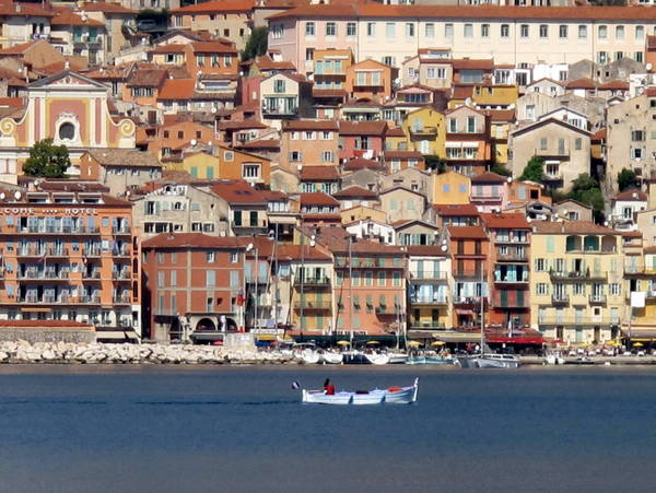
Now included in the Greater Nice, the dazzling little town of Villefranche-sur-Mer on the French Riviera is a pleasant sea resort with its old town made up of colourful façades and red tile roofs, beaches and busy seafront where the terraces of cafés and restaurants overlook the authentic fishing port and one of France’s largest marinas.
Jean Cocteau described it as ‘a source of myth and inspiration’ as its beautiful setting between Mont Baron and the Cap Ferrat peninsula made him feel ‘as if in a box at the opera’.
Watch our short video on the French Riviera, an aerial journey from Toulon to Menton via Saint-Tropez, Cannes, Nice and Monaco ⤵
Plan your trip to Villefranche-sur-Mer!
- 🏨 Find the best accommodations in Villefranche-sur-Mer and the region on Booking.com
- 🙋♀️ Get the PASS CÔTE D’AZUR and take your pick from more than 100 unique experiences!
- 🌴 Read our Discovery Guides of Beaulieu, Eze, La Turbie, Menton, Monaco, Peille and Peillon.
- 🎯 Take a guided hidden gem tour of Monaco
- 🥗 Experience the culture and food of Old Nice on a 4-hour sightseeing and tasting tour
- 📚 Read the DK Eyewitness Provence and the Côte d’Azur Travel Guide
- 🤩 Get familiar with the French Riviera
- 🗺 Download the touristic map of Villefranche-sur-Mer (in PDF)
- 🚻 Public toilets are located near the Gare Maritime and the Tourist Office. Also by Chapelle Sainte-Elizabeth.
- 🚗 Park at Place Wilson by the seafront (very convenient as close to the old town).
- You can get to Villefranche affordably, too, by travelling to Nice by ferry and then taking a 15-minute bus journey to Villefranche. Book your ferry with Stena Line voucher codes and save more on your Villefranche adventure.
Situation of Villefranche-sur-Mer
Today, part of Nice’s suburbs, Villefranche-sur-Mer is a commune situated in the département of Alpes Maritimes, 10 km from Monaco. The three Corniche roads linking Nice to Menton pass through Villefranche, with the Lower Corniche bordering the old town.
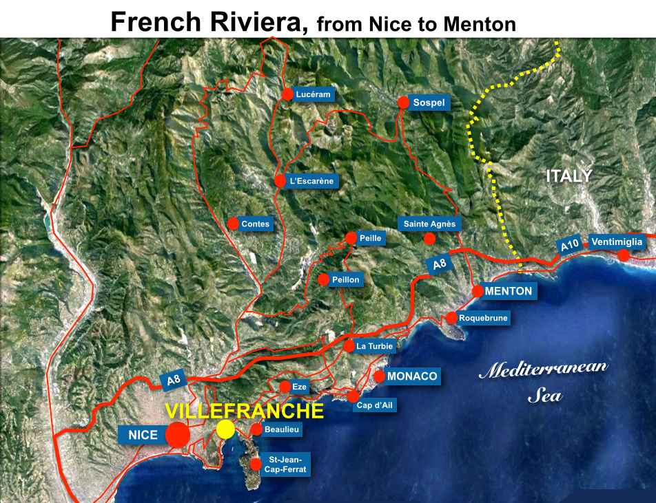
The town owes its importance to its bay (la Rade de Villefranche), one of the deepest natural harbours in the Mediterranean Sea (95 metres), allowing safe anchorage for large ships.
The Cape of Nice borders the Rade de Villefranche to the west and the Cap Ferrat peninsula to the east. The town extends to the surrounding hills, which reach an altitude of 577 metres (Mont Leuze).
Approximately 5,400 inhabitants in Villefranche-sur-Mer are called “Villefranchois” and “Villefranchoises“.
The town is not the only one in France with the same name and should not be confused with Villefranche-sur-Saône and Villefranche-de-Rouergue.
Villefranche: a bit of history
The Greeks and Romans used Villefranche’s natural harbour. The submission of the Alpine people to Rome made the extension of the Via Aurelia (Rome to Pisa) to Gallia Narbonensis possible. Thus, in 14 BC, the Via Julia Augusta, which passed through Villefranche, then known as Olivula Portus, was created.
During the Barbaric Invasions, the harbour repeatedly suffered from invasion from the sea. This led the villagers to abandon the coast to seek refuge in the surrounding hills, where they founded a new village: Montolivo.
![Citadelle of Villefranche-sur-Mer © Jacques Joncour - licence [CC BY-SA 3.0] from Wikimedia Commons](https://frenchmoments.eu/wp-content/uploads/2014/08/Citadelle-of-Villefranche-sur-Mer-©-Jacques-Joncour-licence-CC-BY-SA-3.0-from-Wikimedia-Commons.jpg)
Villefranche (free city or free port) owes its name to Charles II, Duke of Anjou and Count of Provence, who, in 1295, convinced the villagers living in the hills to settle down to the coastline. By building an active seaside town, the strategic bay was less likely to be visited by pirates. Charles II conferred Villefranche a charter, granting tax privileges that were enforced until the 18th century.
In the 14th century, Villefranche and the County of Nice became part of the Duchy of Savoy. The town was important to the House of Savoy as Villefranche was their only maritime gateway.

In 1543, French and Turkish troops under the command of Barbarossa invaded the region and besieged the city of Nice. These events led the Duke of Savoy, Emmanuel Philibert, to fortify the summit of Mont Alban, which overlooks both Villefranche and Nice. Another fortress was built in the rade of Villefranche to prevent any further invasion from the sea: the Saint-Elme citadel, which now houses the town hall.

During the 18th century, Villefranche lost its strategic appeal due to the opening of Nice’s new harbour but kept a busy military and naval base.
Between 1793 and the end of the Napoleonic Empire in 1814, the French occupied Villefranche and the County of Nice. By the Congress of Vienna in 1815, the County was retroceded to the Kingdom of Piedmont-Sardinia. During the 19th century, Villefranche became a home port for the Russian Navy.
In 1860, the County of Nice was given to France following a referendum.
![Villefranche-sur-Mer © Vmenkov - licence [CC BY-SA 3.0] from Wikimedia Commons](https://frenchmoments.eu/wp-content/uploads/2014/08/Villefranche-sur-Mer-©-Vmenkov-licence-CC-BY-SA-3.0-from-Wikimedia-Commons.jpg)
During the Belle Époque, Villefranche attracted celebrities and upper-class visitors during their winter vacations.
The U.S. 6th Fleet of the United States Navy made Villefranche his home port from 1948 until 1966, when France left NATO.
Since then, Villefranche has been a safe anchorage for cruise ships and luxurious yachts and has become one of the busiest marinas in France along with Marseille.
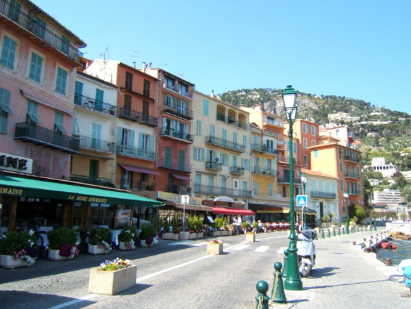
The old town of Villefranche-sur-Mer
The old town of Villefranche-sur-Mer is a cluster of colourful houses topped with red tile roofs above, which rises to the bell tower of Saint-Michel church. The medieval and historic centre of Villefranche-sur-Mer is crossed by narrow cobblestone streets winding up towards the church and Avenue Georges Clemenceau.
Église Saint-Michel
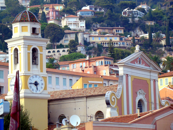
The Saint-Michel church was built in the 1750s on the site of a former sanctuary from the 14th century. It is built in Baroque style with strong Italian influences and contains some interesting sculptures and paintings.
Chapelle Saint-Pierre
![Chapelle Saint Pierre © Remi Jouan - licence [CC BY-SA 3.0] from Wikimedia Commons](https://frenchmoments.eu/wp-content/uploads/2014/08/Villefranche-Chapelle-Saint-Pierre-©-Remi-Jouan-licence-CC-BY-SA-3.0-from-Wikimedia-Commons.jpg)
The Saint-Pierre Chapel is famous for its murals, which were painted by Jean Cocteau. Built in the 16th century, it was used as a storeroom for fishing nets and equipment in the 19th century.
Rue Obscure
![Rue Obscure © Mossot - licence [CC BY-SA 3.0] from Wikimedia Commons](https://frenchmoments.eu/wp-content/uploads/2014/08/Villefranche-sur-Mer-Rue_Obscure-©-Mossot-licence-CC-BY-SA-3.0-from-Wikimedia-Commons.jpg)
The picturesque Rue Obscure or “Dark Street” is a 130-metre long arched passage beneath the houses. Longing the site of the first fortified wall giving onto the sea, the street was first mentioned in 1260. Initially, the street was not covered as it served as the chemin de ronde for soldiers.
Port Royal de la Darse
![Citadelle Saint-Elme Villefranche-sur-mer © Fafou06 - licence [CC BY-SA 3.0] from Wikimedia Commons](https://frenchmoments.eu/wp-content/uploads/2014/08/Citadelle-Saint-Elme-Villefranche-sur-mer-©-Fafou06-licence-CC-BY-SA-3.0-from-Wikimedia-Commons.jpg)
The Dukes of Savoy fortified the Darse Royal Port from 1550 and included the Saint-Elme citadel.
Two centuries later, the port was significantly improved to counter any invasion from the sea by constructing a lighthouse, docks, an arsenal, and a forge. In 1770, a prison, a rope factory, and officers’ barracks were added.
The Lazaret tower is the only tower remaining today out of the three that guarded the citadel. Inside the renovated citadel, Villefranche’s town hall, three museums, an auditorium, a chapel, and an open-air theatre can be found. Today, the Darse Royal Port is one of France’s largest marinas.
How to get to Villefranche-sur-Mer
![The Corniche inférieure at Villefranche-sur-Mer © Vmenkov - licence [CC BY-SA 3.0] from Wikimedia Commons](https://frenchmoments.eu/wp-content/uploads/2014/08/Villefranche-sur-Mer-and-railway-©-Vmenkov-licence-CC-BY-SA-3.0-from-Wikimedia-Commons.jpg)
By car
Villefranche-sur-Mer is easily accessible from Nice via the Corniche Inférieure (Lower Corniche or D6098), which follows the coastline around Mont Boron, or via the D6007-D133 roads, which give more direct access.
By train
The railway station of Villefranche-sur-Mer is situated on the Nice-Ventimiglia TER line and has frequent service.
By air
Nice, France’s third airport after Paris CDG and Orly, is only 12 km from Villefranche-sur-Mer.
English-French Vocabulary
![Villefranche-sur-Mer © Broenberr - licence [CC BY-SA 3.0] from Wikimedia Commons](https://frenchmoments.eu/wp-content/uploads/2014/08/Villefranche-sur-Mer-©-Broenberr-licence-CC-BY-SA-3.0-from-Wikimedia-Commons.jpg)
(f) for féminin, (m) for masculin, (adj) for adjective and (v) for verbs
- Alps = Alpes (f,p)
- bay = baie (f)
- beach = plage (f)
- cape = cap (m)
- citadel = citadelle (f)
- county = comté (m)
- duchy = duché (m)
- Gallia Narbonensis = Gaule narbonnaise (f)
- Greek = Grec (m) / Grecque (f)
- French Alps = Alpes françaises (f,p)
- French Riviera = Côte d’Azur (f)
- harbour = port (m)
- hill = colline (f)
- House of Savoy = Maison de Savoie (f)
- invasion = invasion (f)
- marina = port de plaisance (m)
- Maritime Alps = Alpes Maritimes (f,p)
- Mediterranean Sea = Mer Méditerranée (f)
- mountain = montagne (f)
- port = port (m)
- Roman = Romain (m) / Romaine (f)
- Roman Empire = Empire romain (m)
- Rome = Rome
- war = guerre (f)
Featured image: Villefranche-sur-Mer – licence [CC BY-SA 2.0-uk] from Wikimedia Commons
