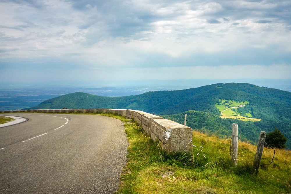

The Route des Crêtes is one of the most spectacular itineraries in the Vosges massif.
It winds along the heights, between forests, mountain passes, high pastures and sweeping panoramas, following part of the ridge line that separates Alsace from Lorraine.
You could describe it as the mountain counterpart to the Alsace Wine Route.
Down below, there are flower-filled villages, vineyards and half-timbered houses. Up above, there are pastures, rounded summits, farm inns, forests and views that sometimes stretch as far as the Black Forest, the Jura and the Alps.
But the Route des Crêtes is not simply a beautiful tourist road. Its history runs deeper.
It was laid out during the First World War to meet military needs on the Vosges front. Today, this once strategic road has become one of the finest itineraries for discovering the High Vosges.
To follow it is therefore to do much more than take a simple drive. It is to cross a mountain landscape, understand a page of history, reach iconic summits such as the Hohneck or the Grand Ballon, stop at a farm inn, and sometimes leave the road behind to walk towards the finest viewpoints.
In this comprehensive guide, I invite you to discover the Route des Crêtes in the Vosges from north to south, with its essential stops, its history, its panoramas and my practical tips for making the most of it.

Route des Crêtes des Vosges - Grand Ballon © French Moments
Route des Crêtes: Understanding This Mythical Vosges Itinerary
Before setting out on the Route des Crêtes, it is useful to understand what makes it so distinctive.
It is not merely a mountain road. It is a ridge itinerary, a former strategic axis, a balcony over Alsace and Lorraine, and one of the finest gateways to the high-altitude landscapes of the Vosges.
Where does the Route des Crêtes begin and end?
Technically, the Route des Crêtes runs from Sainte-Marie-aux-Mines to Uffholtz, at the foot of the massif, not far from Cernay and Thann.
In practice, many travellers join it via the Col du Bonhomme, the Kaysersberg valley, the Col de la Schlucht, the Grand Ballon or Le Markstein.
That is one of the advantages of this itinerary: you can drive the whole route or discover only a section of it, depending on how much time you have.
The road generally follows a north-south direction. It crosses several emblematic areas of the High Vosges, including the Gazon du Faing, the Col de la Schlucht, the Hohneck, Le Markstein, the Grand Ballon and the Hartmannswillerkopf – Vieil Armand.
On the map, the itinerary may seem quite simple. On the ground, it is far richer. Each section reveals a different atmosphere: conifer forests, deep valleys, open high pastures, mountain resorts, farm inns, glacial lakes and panoramas over the Alsace Plain.
The Route des Crêtes between Alsace and Lorraine
The Route des Crêtes largely follows the main ridge line of the Vosges, which long formed a natural frontier between Alsace and Lorraine.
This situation explains part of its charm. At times the road looks towards the Lorraine side, with its gentler slopes and deep valleys; at other moments it opens onto the Alsatian side, often steeper, with plunging views towards the Rhine Plain.
In some places, you almost pass from one world to another in just a few bends. On one side are the upper Lorraine valleys; on the other, Alsace, with its villages, vineyards and, further away, the dark line of the Black Forest on the horizon.

The Swiss Alps seen from the Grand Ballon © French Moments
This frontier position also played a major role in history. After 1871, the Vosges line became the boundary between France and the German Empire. During the First World War, the ridges took on considerable strategic importance. The road was then developed to allow north-south communication along the Vosges front.
Today, this military origin is discreet. When admiring the landscapes, it is easy to forget that this road was first conceived for war. And yet the memory of 1914-1918 remains present, especially at the Hartmannswillerkopf – Vieil Armand, one of the great places of remembrance crossed by the Route des Crêtes.
The High Pastures, the Landscape Soul of the Ridge Road
What often surprises visitors on the Route des Crêtes is the high pastures (in French, les Hautes Chaumes).
You expect forests, of course. The Vosges have plenty of those — more than enough, in fact. But suddenly, the road emerges into vast open spaces, upland pastures, rounded summits and wide horizons. The landscape changes scale.

Hautes-Chaumes in the Vosges © French Moments
These high pastures give the Vosges their distinctive silhouette. They cover the upper parts of the massif and offer that unique blend of softness and grandeur.
Nothing like the Alps, of course. Here, the mountains are rounder, more accessible, perhaps less spectacular, but often more intimate.
From these open spaces, the views can be magnificent. You can see the Vosges valleys, the Alsace Plain, the Black Forest, the Jura and, when conditions are favourable, the Alps.
The high pastures are also linked to pastoral life. Herds would spend the summer there, and the milk was used in particular to make Munster cheese. Even today, the farm inns recall this agricultural and mountain heritage. They are an essential part of the Route des Crêtes experience.
Because let us be honest: we come for the panoramas, of course. But when a farm inn appears around a bend in the path, with a blueberry tart or a repas marcaire waiting at the end, the meaning of the journey suddenly becomes much more concrete.
The History of the Route des Crêtes
The Route des Crêtes first impresses with its landscapes. Yet its origin is not touristic. Before becoming one of the most beautiful panoramic roads in the Vosges, it was created in a context of frontier, war and military strategy.
That contrast is what makes the itinerary so interesting. Today, people stop here to admire the high pastures, photograph the summits, eat in a farm inn or breathe the fresh air of the heights.
But this road was also born from a period when the Vosges ridges occupied a sensitive place in European history.

Monument des Diables Bleus © French Moments
The Route des Crêtes and the Franco-German Frontier after 1871
To understand the history of the Route des Crêtes, we need to go back to the Franco-Prussian War of 1870 and the Treaty of Frankfurt in 1871.
After the French defeat, Alsace and part of Lorraine were annexed by the German Empire. The Vosges line then became far more than a geographical boundary. It marked a political, military and symbolic frontier between France and Germany.
On the heights, this frontier largely followed the ridge of the massif. On one side lay annexed Alsace; on the other, Lorraine, which remained French. The passes, summits, high pastures and forests then took on a new importance.
It was in this context that the famous expression “ligne bleue des Vosges” — the “blue line of the Vosges” — emerged and became popular in the late 19th century. From France, the Vosges became a horizon charged with emotion, memory and expectation. People no longer looked merely at a mountain: they looked at a frontier.
This dimension explains why, when the First World War broke out in 1914, the Vosges ridges quickly became a strategic sector.

Panorama over the Thur Valley from the Grand Ballon © French Moments
The Route des Crêtes during the First World War
During the Great War, the Vosges massif formed one of the mountain fronts of the conflict.
In this difficult terrain, roads were essential. Men, food, ammunition, equipment and medical supplies had to be transported. Positions had to be connected, defences organised, and movement along the front made possible.
The Route des Crêtes was therefore developed for strategic purposes. It allowed north-south communication on the heights, close to the ridge line, while facilitating logistics and the defence of the Vosges front.

Boundary stone between Alsace and Lorraine at the Col de la Schlucht © French Moments
So this was not a road designed for tourists in search of a beautiful sunset over the Alsace Plain. Not exactly. Its original role was military.
Some sections already existed, but the war effort led to the completion and organisation of this mountain itinerary. The route also sought, wherever possible, to protect movements from enemy observation. In a massif where one can see far, not being seen could become a matter of life and death.
When you drive along the Route des Crêtes today, this military origin is not always obvious. The landscapes seem peaceful, the high pastures welcoming, the farm inns reassuring. Yet several places recall the violence of this history, especially around Le Linge, the Hartmannswillerkopf – Vieil Armand, and former positions on the Vosges front.
From Military Road to Tourist Route
After the war, the Route des Crêtes gradually changed purpose.
What had been designed for movement in a military context slowly became an itinerary of discovery. Motorists, hikers, cyclists and mountain lovers found in it privileged access to some of the finest landscapes in the Vosges.

L'arrivée au col Amic © French Moments
This transformation is quite fascinating.
A road born of war became a road of freedom. Military movements gave way to family outings, photo stops, hikes towards the summits and repas marcaire meals in farm inns. The same heights once watched, defended and contested are now explored for their beauty.
The Route des Crêtes has therefore kept a double identity. It is both a historic itinerary and a road of fresh mountain air. It tells the memory of the massif while offering one of the finest introductions to the landscapes of the High Vosges.
Perhaps that is what makes it so endearing: it does not erase its past, but has transformed it into a path of discovery.
Following the Route des Crêtes from North to South
The Route des Crêtes can be travelled in either direction. But I find it particularly spectacular from north to south.
Why? Because the itinerary gradually builds in intensity. You begin in the Bonhomme and Gazon du Faing sectors, cross the great Hohneck and high pastures area, then reach Le Markstein, the Grand Ballon and finally the descent towards Vieil Armand and the Alsace Plain.

The route at the Gazon du Faing © French Moments
In this direction, the road almost gives the impression of a story. It begins gently, gains altitude, reveals its great landscapes, then ends with a series of impressive views over the Alsace Plain.
And if you enjoy combining mountains and vineyards, you can even imagine a complete loop: the Alsace Wine Route in one direction, the Route des Crêtes in the other. Down below, the vines. Up above, the high pastures. It is hard to get more Alsatian than that without adding a tarte flambée somewhere in between.
From the Col du Bonhomme to the Gazon du Faing
The northern section of the Route des Crêtes is easy to reach from Sainte-Marie-aux-Mines, the Kaysersberg valley or the Col du Bonhomme.
The Col du Bonhomme, at an altitude of 949 metres, is one of the great historic crossings of the Vosges. It links the Alsatian side, around the Kaysersberg valley, with the Lorraine side, towards Saint-Dié-des-Vosges and the Meurthe valley.

At the col du Bonhomme © French Moments
From there, the road gains height and crosses landscapes of forests and passes. It passes through the Col du Louchpach and Col du Calvaire sectors before reaching the Gazon du Faing.
The Gazon du Faing is one of the first great moments of the itinerary. From the road, you often only need to walk a little to leave the world of cars behind and enter the world of the high pastures.

The view over the Alsatian side from the Gazon du Faing © French Moments
This is an important detail: although the Route des Crêtes is a road, its finest landscapes are often discovered on foot. Sometimes you need to park, walk for a few minutes, and reach a ridge, a viewpoint or a nearby summit. That is where the magic really happens.
At the Gazon du Faing, the view drops towards the Alsatian side, the mountain lakes, the forests and the plain. The contrast with the gentler Lorraine side is one of the great charms of this section.
The Col de la Schlucht, an Emblematic Stop on the Route
Continuing south, the Route des Crêtes reaches the Col de la Schlucht.
It is undoubtedly one of the best-known passes in the Vosges massif. It links the Alsatian Munster valley with the Lorraine valleys of the Meurthe and the Vologne. It is also a very busy crossing point between Colmar and Gérardmer.

The Col de la Schlucht © French Moments
La Schlucht has a long tourist history. As early as the Belle Époque, the pass attracted visitors, hotels, skiers and walkers. Today, you will still find shops, restaurants, leisure activities and several hiking trailheads.
Its name, which evokes a gorge or defile, recalls the enclosed character of the crossing. And, incidentally, good luck pronouncing it perfectly the first time. The Vosges sometimes like to test visitors with their landscapes, but also with their consonants.

Summer toboggan run at the col de la Schlucht © French Moments
From the pass, several paths can be followed, especially towards the ridges, the Frankenthal or the Hohneck. For many travellers, La Schlucht is a practical stop. For hikers, it is above all a gateway to some of the most powerful landscapes in the massif.
The Hohneck, a Major Summit on the Route
Shortly after La Schlucht, the Route des Crêtes approaches the Hohneck.
At 1,363 metres above sea level, the Hohneck is one of the most emblematic summits in the Vosges. It is easily recognisable thanks to the building near its summit, but also because of its highly contrasting relief.

The hotel-restaurant at the summit of the Hohneck © French Moments
To the west, on the Lorraine side, the slopes are gentler and descend towards valleys and lakes. To the east, on the Alsatian side, the relief becomes much more abrupt, with rocky slopes, glacial cirques and landscapes that suddenly feel wilder.
This is one of the places where you best understand the geography of the Vosges. The massif is not symmetrical. The Alsatian side often drops more sharply towards the plain, while the Lorraine side stretches out more gradually.

Orientation table at the Hohneck © French Moments
You can reach the summit of the Hohneck by a small regulated road, or continue on foot from the car park near the inn below the summit. The climb is not very long, but it gives access to a remarkable panorama.
On a clear day, the view stretches towards the Vosges summits, the Alsace Plain, the Black Forest, the Jura and sometimes the Alps. To the west, you discover the Lorraine Vosges and the Lorraine plateau.
This is not a stop to rush. If the weather is clear, take the time to climb to the summit. The Route des Crêtes is beautiful from the car, but it becomes truly memorable when you leave the tarmac behind.
From the Rainkopf to Le Markstein via the High Pastures
After the Hohneck, the Route des Crêtes crosses one of its most characteristic sections: the high pastures between the Rainkopf and Le Markstein.
Here, the road alternates between forest passages, views over the Lorraine valleys, glimpses towards the lakes, and then more open spaces. Farm inns punctuate the route and remind us that these landscapes are not only tourist sites: they are also linked to a long pastoral history.
The Rainkopf sector marks an important transition. The road threads its way along the heights, with views towards Lorraine, then gradually moves into a more distinctly Alsatian section.

Farm inn near the Rainkopf © French Moments
You then discover the valleys on the eastern side of the Vosges, especially the upper Thur Valley and the Lac de Kruth-Wildenstein area. The landscapes become more open, the high pastures more present, and you sense that you are approaching the great summits of the southern massif.
Le Markstein is then an important crossroads. It is at once a winter sports resort, a summer leisure site, a hiking departure point and a well-known passage for cyclists.
You can stop here to walk, reach the nearby ridges, look out over the Thur Valley or continue towards the Grand Ballon. Le Markstein may not be the most intimate place on the Route des Crêtes, but it plays a central role in the organisation of the massif.

Col du Haag seen from the Grand Ballon © French Moments
The Grand Ballon, the Highest Point in the Vosges
From Le Markstein, the Route des Crêtes continues towards the Grand Ballon.
At 1,424 metres above sea level, the Grand Ballon is the highest point in the Vosges.
Its summit is easily identifiable thanks to the large radar station that dominates the landscape. It may not be the most romantic feature of the massif, but it does at least help you recognise the mountain from afar.

Arriving at the summit via the Route des Crêtes © French Moments
The road reaches the Col du Grand Ballon area, where you can park before walking up towards the summit. The final climb is relatively short, but it is truly worth the effort.
From the summit, the panorama is one of the widest in the Vosges. You can see the ridges, the valleys, the Alsace Plain, the Black Forest, the Jura and, on a clear day, the Alps. Sometimes even Mont Blanc appears on the horizon, which always adds a little extra emotion to the visit.
The Grand Ballon is one of the places where the Route des Crêtes takes on its full scale. You are no longer simply crossing a massif. You dominate it, read it and understand it.

The Route des Crêtes in winter at the Grand Ballon © French Moments
It is also a good place to measure the difference between altitude and a sense of grandeur. The Vosges do not rival the Alps in absolute height. But from the Grand Ballon, the view over the Rhine Plain and the distant horizons gives a real sense of space.
From the Grand Ballon to Vieil Armand
After the Grand Ballon, the Route des Crêtes begins its descent towards the south.
This section still offers some very beautiful landscapes. The views over the Alsace Plain can be superb, especially when the light drops over the valleys and the relief of the Black Forest appears on the horizon.
Along the way, several sites deserve attention.
The Sudel Chapel recalls the memory of the soldiers who fell in the fighting at Vieil Armand.
Col Amic, for its part, is named after Captain Paul Amic, killed in 1915 at the Hartmannswillerkopf.
A little further on, the ruins of Freundstein Castle dominate the area at over 900 metres above sea level.

The ruins of Freundstein Castle © French Moments
Then the road approaches the Hartmannswillerkopf – Vieil Armand, one of the great First World War memorial sites in the Vosges.
The contrast is striking: after open landscapes, high pastures and panoramas, you enter a site marked by history, reflection and Franco-German remembrance.

The national cemetery of Vieil Armand © French Moments
This is one of the strengths of the Route des Crêtes. It does not only offer beautiful landscapes. It also links places charged with meaning.
As you continue towards Uffholtz, Cernay and Thann, you gradually leave the mountains behind and return to the Vosges foothills and the Alsace Plain. The road descends, but the impression remains.
The Route des Crêtes is not simply a panoramic itinerary. It is a journey along a line of division: between Alsace and Lorraine, between mountain and plain, between nature and history.

The Thann Gate in Cernay © French Moments
The Most Beautiful Stops on the Route des Crêtes
The Route des Crêtes is enjoyed as much through its great landscapes as through its stops. Some sites are almost unmissable, while others require you to leave the car for a few minutes, sometimes longer.
This is worth remembering: you do not truly discover the Route des Crêtes by staying constantly behind the windscreen. Of course, the road is beautiful in itself. But its finest moments are often found just a few steps from a car park, at the end of a path, on a high pasture or near a summit.
Here are a few stops to prioritise if you want to make the most of the itinerary.
The Gazon du Faing

Path at the Gazon du Faing © French Moments
The Gazon du Faing is one of the first great high-altitude sites when travelling along the Route des Crêtes from the north.
It is an ideal place to understand the atmosphere of the High Pastures: wide open spaces, plunging views towards the Alsatian side, ridge paths and that feeling of walking above the world without needing to reach Alpine altitudes.
From the surrounding area, you can enjoy beautiful views towards the lakes, forests and Alsace Plain. It is also a popular area for hikers, but it is important to stay on the marked paths in order to protect the fragile natural environments.
The Gazon du Faing is a good example of what the Route des Crêtes offers at its best: easy access to a landscape that nevertheless feels wonderfully wild.
The Col de la Schlucht, a Major Stop on the Route

Lake Longemer between the Schlucht Pass and the Hohneck © French Moments
The Col de la Schlucht is one of the best-known places on the Route des Crêtes.
It is an important crossroads between Alsace and Lorraine, but also a very practical starting point for hikes. From the pass, you can reach the ridges, head towards the Hohneck, descend into wilder landscapes or simply take a break before continuing along the route.
The site is more developed than other sections of the road. There is more traffic, more shops and more activities. It is therefore not the most peaceful stop, especially in high season.
But it remains essential for understanding the tourist history of the Vosges. La Schlucht has long been one of the great gateways into the massif.
The Hohneck, a Major Summit on the Route

Lake Longemer seen from the Hohneck © French Moments
The Hohneck is one of the most spectacular stops on the Route des Crêtes.
You can approach it easily from the road, then reach the summit on foot. The final climb is not very long, but it completely changes the experience. Once at the top, the view opens out over the Vosges, the Lorraine valleys, the glacial cirques on the Alsatian side and, on a clear day, the distant horizons.
The Hohneck is also one of the places where the contrast between the two sides of the massif is most obvious. On the Lorraine side, the relief seems gentler. On the Alsatian side, the slopes become steeper, almost Alpine in places.
If you only make one short walking detour on the Route des Crêtes, the Hohneck clearly deserves its place on the list.
Le Markstein, a Lively Crossroads on the Route

Lake Kruth and the upper Thur Valley seen from the area around Le Markstein © French Moments
Le Markstein is another important stop, especially in the southern part of the Route des Crêtes.
It is a more open, more lively site: at once a winter sports resort, a summer leisure area, a road crossing, a hiking departure point and a well-known place for cyclists. It does not always have the intimate charm of an isolated high pasture, but it plays a central role in this part of the High Vosges.
From Le Markstein, you can follow several walking routes, enjoy views over the high pastures, or continue towards the Grand Ballon. It is also a useful landmark when planning a day in the southern part of the massif.
Le Markstein reminds us that the Route des Crêtes is not only a contemplative road. It is also a living, busy, sporting and family-friendly space.
The Grand Ballon, the Highest Point on the Route

Grand Ballon seen from the Col du Haag © French Moments
The Grand Ballon is one of the great highlights of the Route des Crêtes.
At 1,424 metres above sea level, it dominates the entire Vosges massif. From the Col du Grand Ballon, a short climb leads to the summit and its wide panorama.
On a clear day, the view is exceptional: the Vosges ridges, the Alsace Plain, the Black Forest, the Jura and sometimes the Alps. It is one of the best places to understand the scale of the massif and its position between France, Germany and Switzerland.
The Grand Ballon attracts many visitors, especially in fine weather. But even when it is busy, it remains impressive. It has the strength of summits that are easy to reach: you arrive without needing a complicated expedition, but the emotion of the landscape is very real.
The Hartmannswillerkopf – Vieil Armand, Memory on the Route
![Hartmannswillerkopf Cemetery. Photo by Evadb [Public Domain via Wikimedia Commons]](https://frenchmoments.eu/wp-content/uploads/2026/07/Hartmannswillerkopf-Cemetery.-Photo-by-Evadb-Public-Domain-via-Wikimedia-Commons-1.jpg "Hartmannswillerkopf Cemetery. Photo by Evadb [Public Domain via Wikimedia Commons]")
Hartmannswillerkopf Cemetery. Photo by Evadb [Public Domain via Wikimedia Commons]
The Hartmannswillerkopf, also known as Vieil Armand, brings a more solemn dimension to the Route des Crêtes.
After the high pastures, panoramas and summits, this site reminds us that the Vosges were also a war front. The national monument, the cemetery, the Franco-German historial and the remains of the battlefield together form one of the great First World War memorial sites in Alsace.
This is a stop to approach differently. You do not come here simply to admire a view or take a break on the road. You come to understand, to reflect, and to measure what this landscape has been through.
Vieil Armand shows the full richness of the Route des Crêtes: it is not only panoramic. It is also historical, human and memorial.
The Farm Inns of the Route des Crêtes

Farm inn with a view over the Thur Valley © French Moments
It is impossible to talk about the best stops without mentioning the farm inns.
They are part of the identity of the High Vosges. You find them near the high pastures, beside the road or after a walk of varying length. Some are very well known, others more discreet, but all recall the link between mountain, pastoral life and gastronomy.
People come for a repas marcaire, a blueberry tart, cheese, potatoes, a generous plate of food or simply a break in a mountain setting.

A slice of Vosges blueberry tart © French Moments
Of course, in high season, it is often better to book. A Vosges farm inn may look rustic and peaceful, but it can attract quite a crowd. The power of a blueberry tart should never be underestimated.
The Small Stops that Give the Ridge Drive its Charm
Finally, the Route des Crêtes is not only about the famous names.
Sometimes, the best memories come from an improvised stop: an unnamed viewpoint, evening light over the Alsace Plain, a sea of cloud above the valleys, a short walk across a high pasture or a bench facing the summits.

Fountain near the Rainkopf © French Moments
That is why you should not travel the road too quickly. It deserves pauses, detours and moments of waiting. The Vosges do not always reveal themselves through immediate spectacle. They often reveal themselves in the details: the curve of a mountain, a dark forest, an isolated farm, a horizon suddenly opening wide.
The Route des Crêtes is therefore as much an itinerary as an invitation to slow down.
The Route des Crêtes on Foot, by Bike or by Car
The Route des Crêtes can be discovered in several ways. The car makes it easy to cover the main stages. Walking allows you to grasp its deepest beauty. Cycling adds a sporting dimension that completely changes your relationship with the landscape.
Because on the Route des Crêtes, everything depends on the speed at which you travel.
By car, you admire the panoramas. On foot, you inhabit them. By bike, you earn them.
Driving the Route des Crêtes by Car
The car remains the easiest way to discover the Route des Crêtes, especially if you want to cover a large part of the itinerary in a single day.
It allows you to link the main sites easily: Gazon du Faing, Col de la Schlucht, Hohneck, Le Markstein, Grand Ballon, Vieil Armand and the descent towards the Alsace Plain.

Directions for the Route des Crêtes des Vosges at Uffholtz © French Moments
But the experience should not be reduced to a simple succession of car parks. The charm of the Route des Crêtes also lies in unexpected stops, short walks, viewpoints and detours. Some landscapes reveal themselves only to those who take the time to get out of the car.
In high season, especially on summer weekends, traffic can be heavy around the best-known sites. It is better to leave early, allow plenty of time, and accept that the mountains do not much like overly tight schedules.
They prefer pauses. And often, they are right.
Why You Sometimes Need to Leave the Route des Crêtes on Foot
Even though the Route des Crêtes is a panoramic road, its finest landscapes are not always visible directly from the road itself.
Sometimes all it takes is a ten- or fifteen-minute walk to reach a high pasture, a viewpoint, a summit or a ridge path. That is when you truly understand the power of the Vosges massif.

Path at the Gazon du Faing © French Moments
From the Gazon du Faing, the Hohneck, the Grand Ballon or the high pastures near Le Markstein, walking allows you to move from a simple view to real immersion. You hear the wind, feel the relief, observe the valleys and discover angles that the car cannot offer.
It is important, however, to stay on the marked paths. The High Pastures are fragile environments, exposed to trampling, erosion and tourist pressure. The beauty of these places also depends on our ability not to walk just anywhere.
The Vosges are welcoming, but they are not a wasteland. Even the blueberries deserve a little peace and quiet.
The Route des Crêtes by Bike
The Route des Crêtes is also a very popular itinerary among cyclists.
It combines everything that gives cycling in the Vosges its charm — and sometimes its difficulty: long climbs, sequences of passes, forest roads, open sections across the high pastures, sudden views over the Alsace Plain and descents that require attention.
There is no shortage of great cycling sectors: the climb towards the Col de la Schlucht, the roads around the Hohneck, the approach to Le Markstein, the ascent of the Grand Ballon, and the passages towards Vieil Armand and Col Amic.

The Route des Crêtes on the slopes of the Grand Ballon © French Moments
These may not be the Alps, but the Vosges know very well how to make calves suffer. They sometimes do it with a smile, offering a fine view at the top, but the calves do not forget.
For cyclists, the Route des Crêtes is particularly interesting because it allows several efforts to be linked together. You are not simply on one isolated climb, but on a mountain itinerary that plays with ridges, passes and valleys.
The Route des Crêtes and the Tour de France
The Tour de France has often helped bring the roads of the Vosges to the attention of the wider public. The Grand Ballon, Le Markstein, the Hohneck, the Ballon d’Alsace and Vieil Armand now all belong to the cycling imagination of the massif.
The Route des Crêtes and its neighbouring roads form ideal terrain for the Grande Boucle: the gradients are not always endless, but the sequences can be formidable. Riders move from one valley to another, climb towards the ridges, descend, accelerate again, then meet another difficulty.

The high pastures © French Moments
In 2026, the Mulhouse – Le Markstein Fellering stage will put the High Vosges back in the spotlight. The route will cross several emblematic sectors of the southern massif, with a finish at Le Markstein, one of the great sites on the Route des Crêtes.
For television viewers, it will be a magnificent showcase for the Vosges landscapes. For the riders, it will probably be a rather less contemplative day.
That is also what makes the Route des Crêtes so interesting: it can be a family outing, a tourist road, a hiking route, a cycling terrain or a Tour de France stage. It all depends on how you approach it.
The Route des Crêtes by Motorbike: Panoramas and Caution
The Route des Crêtes also attracts many motorcyclists.
It is easy to understand why: the bends, views, passes and changing atmospheres make it an enjoyable itinerary. But this popularity also calls for caution, especially in high season.
The road is shared with cars, cyclists, camper vans, pedestrians near car parks and sometimes even animals. Some sections are narrow, bends can be surprising, and the weather changes quickly at altitude.

The Route des Crêtes near the Rainkopf © French Moments
The Route des Crêtes is not a racing circuit. It is a mountain road, in a fragile and very busy environment. The pleasure of travelling along it must therefore remain compatible with respect for other road users and for the landscapes.
After all, if you go up to the ridges, it is to enjoy the beauty of the massif, not to turn the high pastures into an imaginary straight line.
Practical Tips for Visiting the Route des Crêtes
The Route des Crêtes looks simple on a map. A beautiful mountain road, a few passes, summits, panoramic stops — and that is that.
In reality, to enjoy it properly, it is best to plan a little. The weather can change quickly, some areas are very busy in summer, and the finest moments of the day are not always the ones you expect.
Here are a few practical tips to help you organise your discovery of the Route des Crêtes in the best conditions.

The lac des Truites seen from the Gazon du Faing © French Moments
What is the best time of year to drive the Ridge Road?
The best time to drive the Route des Crêtes generally runs from late spring to early autumn.
In May and June, the landscapes turn green again, the high pastures regain their colour and visitor numbers are often more reasonable than in high summer. July and August offer the longest days, but also more people, especially around the Hohneck, the Grand Ballon, Le Markstein and the Col de la Schlucht.

Rain on the Lorraine side at the Gazon du Faing © French Moments
September is probably one of the most beautiful months for discovering the Route des Crêtes. The light becomes softer, the panoramas are often magnificent, and the atmosphere is calmer after the high season.
Autumn can be superb, especially when the forests take on their colours. But the days become shorter, the weather more changeable, and the first winter conditions can arrive quite quickly on the heights.
In the Vosges, the altitude may seem modest on paper, but the mountains know how to remind you that they have their own calendar. They do not always consult the tourists before bringing down the fog.
Is the Route des Crêtes open in winter?
The Route des Crêtes is not open all year round along its entire length.
Some sections are closed during the winter period, depending on snow, ice and driving conditions. The closure often begins around mid-November, with reopening in spring depending on snow cover and decisions by the local authorities.
It is therefore essential to check road conditions before setting out, especially between November and April. Conditions can vary from one section to another: one stretch may be accessible while another remains closed.

Winter closure of the Route des Crêtes at the Grand Ballon © French Moments
This does not mean that the ridges lose all interest in winter. Quite the opposite: the landscapes can be magnificent under snow. But access is then different: from resorts, open car parks, snowshoe routes, cross-country ski trails or managed areas.
In winter, the Route des Crêtes becomes less of a panoramic road and more of a mountain territory. And that completely changes the experience.
How long does it take to drive the Route des Crêtes?
Technically, you can drive a large part of the Route des Crêtes in a few hours.
But that would really mean missing the point.
For a first discovery, I recommend allowing at least a full day. This gives you time to drive calmly, stop at the main viewpoints, walk a little, have lunch in a farm inn and enjoy the landscapes without constantly looking at the clock.
If you enjoy hiking or photography, two days will not be too much. You can then devote one day to the northern section, around the Gazon du Faing, La Schlucht and the Hohneck, and another to the southern section, around Le Markstein, the Grand Ballon and Vieil Armand.
The Route des Crêtes is not a mountain motorway. It is an itinerary to be savoured in fragments, pauses and detours.
What is the best time of day for panoramas?
For panoramas, the finest moments are often morning and late afternoon.
In the morning, the light is softer, the air may be clearer and visitor numbers are generally lower. It is an excellent time for photos, especially if you want to enjoy the calm on the high pastures or around the summits.

Signpost for the Grand Ballon © French Moments
Late afternoon offers another atmosphere. The light drops, the relief becomes better defined, the Alsace Plain sometimes takes on golden tones, and the long shadows give greater depth to the landscape.
At midday, the light can be harsher, especially in summer. But it is also the ideal time for a break in a farm inn. As you can see, even imperfect light can have its compensations.
Where can you see the Alps from the Route des Crêtes?
On a very clear day, it is possible to see the Alps from several sections of the Route des Crêtes.
The best viewpoints are found especially around the Hohneck, Le Markstein, the Grand Ballon and the Hartmannswillerkopf – Vieil Armand. The Grand Ballon, the highest point in the Vosges, is one of the best places to hope to distinguish the Alpine summits on the horizon.
But let us be honest: seeing the Alps from the Vosges is never guaranteed. It all depends on the weather, the clarity of the air, the season and the light.

Mont Blanc, right, and the Chasseral, left, seen from the Grand Ballon © French Moments
Cold, clear days, especially after a change in weather, often offer the best chances. When the Alps appear, it is always a small event. You came for the Vosges, and suddenly your gaze travels far beyond the plain, the Jura and Switzerland.
Where to eat on the Route des Crêtes?
Farm inns are part of the Route des Crêtes experience.
They recall the pastoral history of the High Pastures and offer generous mountain food: repas marcaire, pies, cheeses, potatoes, blueberry tarts and other Vosges specialities.
You will find farm inns in several parts of the itinerary, especially around the Gazon du Faing, the Hohneck, Le Markstein, the Grand Ballon and the neighbouring high pastures.

Ferme auberge du Haag © French Moments
In high season, it is better to book, especially at weekends. Some addresses are very well known and can quickly fill up. It is also worth checking opening days and periods, as not all farm inns operate in the same way depending on the season.
And then, it is best to keep a little flexibility. In the Vosges, a good farm inn at the right moment can turn a simple day on the road into a lasting memory. Especially if a blueberry tart decides to join you at the table.
What should you prepare before setting off?
Even though the Route des Crêtes is easily accessible, it remains a mountain road.
It is better to bring suitable clothing, even in summer. The wind can be cool on the high pastures, fog can arrive quickly, and the temperature changes noticeably between the Alsace Plain and the summits.
Also bring good shoes if you plan to walk, even for short outings. Some paths can be stony, damp or slippery.

The Col du Haag and the Storkenkopf © French Moments
For photography, check the weather, but also the visibility. A perfectly sunny day on the plain does not always guarantee clear panoramas on the ridges. Conversely, a sea of cloud can offer an extraordinary spectacle from the heights.
Finally, leave some free time in your programme. The Route des Crêtes rarely rewards those who want to tick everything off too quickly. It prefers travellers who stop, look, walk a little, change their mind, take a secondary road, and accept that the mountain has the final say.
Around the Route des Crêtes
The Route des Crêtes can of course be discovered on its own. But it makes even more sense when placed within its wider surroundings.
It dominates the Alsatian valleys, reaches the great Vosges summits, crosses places of remembrance, and wonderfully complements other tourist routes in Alsace-Lorraine.
If you have a little time, here are a few ideas for extending your discovery.
The Alsace Wine Route, the counterpart to the Route des Crêtes

The Alsace Wine Route in Hunawihr © French Moments
The Alsace Wine Route forms a magnificent contrast with the Route des Crêtes.
Down below, there are wine villages, half-timbered houses, vineyards, ramparts and cellars. Up above, there are high pastures, passes, summits, farm inns and wide panoramas.
The two itineraries tell two complementary stories of Alsace.
The Wine Route reveals the Alsace of villages, heritage and vineyards.
The Route des Crêtes reveals mountain Alsace, rougher, more open and sometimes more silent.
That is why I like to combine them. You can very easily imagine a stay that brings the two together: one day in the villages of the Wine Route, then one day on the Vosges heights. It helps you understand just how quickly Alsace changes face once you leave the plain and climb towards the ridges.
And, let us be honest: alternating white wine tasting with walking across the high pastures is quite an effective way of balancing pleasures.
The Alsatian Valleys at the Foot of the Route des Crêtes
The Route des Crêtes dominates several great Alsatian valleys.
From its heights, you can reach or glimpse the Munster Valley, the Thur Valley, the Doller Valley, the Lauch Valley, or the areas around Kaysersberg and Sainte-Marie-aux-Mines.

Kaysersberg Valley © French Moments
These valleys are essential for understanding the itinerary. They serve as gateways, starting points, places to stay, and transitions between the plain and the mountains.
Each has its own character. The Munster Valley is strongly linked to the high pastures and cheese-making tradition. The Thur Valley leads towards Le Markstein, the Grand Ballon and the Lac de Kruth-Wildenstein. The Doller Valley opens towards the Ballon d’Alsace, the Lac d’Alfeld and the wilder landscapes of the southern Vosges.
The Route des Crêtes offers the great horizons. The valleys, however, give the massif its human depth: villages, rivers, former industries, traditions, hiking routes and memories of local life.
Route Joffre, between the Doller and the Thur
Route Joffre is another fascinating Vosges road, shorter and more discreet than the Route des Crêtes.
It links the area around Masevaux, in the Doller Valley, with Bitschwiller-lès-Thann, in the Thur Valley, passing through Houppach, the Col du Schirm, Bourbach-le-Haut and the Col du Hundsruck.

On the heights of the Rossberg massif © French Moments
Like the Route des Crêtes, it has origins linked to the First World War. It reminds us that the mountain roads of the Vosges are not merely tourist itineraries. Many also have a military, strategic or memorial history.
Today, Route Joffre is appreciated by motorists, cyclists and hikers. The Col du Hundsruck is a particularly good starting point for walks towards the Rossberg massif, the Thannerhubel and the farm inns of the area.
It is a fine extension for anyone wishing to discover the southern Vosges beyond the great classics.
The Ballon d’Alsace, Another Great Summit of the Southern Vosges

Hiking in the Ballon d’Alsace massif © French Moments
Although it is not directly on the classic Route des Crêtes, the Ballon d’Alsace makes a beautiful extension to the south.
Located at the meeting point of Alsace, Lorraine and Franche-Comté, it is one of those emblematic summits that tell the complex geography of the Vosges massif.
There are fine panoramas, hiking opportunities, a family-friendly mountain atmosphere and a history strongly linked to former frontiers. The Ballon d’Alsace also allows you to extend your discovery towards the Doller Valley, the Lac d’Alfeld, Sewen or the Territoire de Belfort.
For those who love great mountain itineraries, it can naturally complement a discovery of the Route des Crêtes.

The Doller Valley © French Moments
Thann, Cernay and the Return to the Alsace Plain
At the southern end of the Route des Crêtes, the descent towards Uffholtz, Cernay and Thann marks the return to the Alsace Plain.
It is an interesting transition. After the high pastures, summits and passes, you find villages, vineyards, small historic towns and the landscapes of the Vosges foothills once again.
Thann particularly deserves a stop. With its Collegiate Church of Saint-Thiébaut, its Rangen vineyard and its position at the entrance to the Thur Valley, the town makes a fine conclusion to the itinerary.

Thann in winter © French Moments
Cernay, Uffholtz and the neighbouring villages also remind us that the Route des Crêtes does not exist in isolation. It belongs to a complete territory, between mountain, memory, vineyard and plain.
Perhaps that is what gives this itinerary its richness: you begin on the heights, but very quickly understand that the ridges only fully make sense in dialogue with the valleys and the plain.
FAQ about the Route des Crêtes
The Route des Crêtes is about 88 kilometres long between Sainte-Marie-aux-Mines and Uffholtz, near Cernay.
That may seem quite reasonable, but this itinerary should not be judged by its length alone. The road crosses mountain areas, with numerous passes, bends, panoramic stops and hiking opportunities.
If you really want to enjoy the route, it is best to allow plenty of time. The Route des Crêtes is not a road to “do” quickly. It is a road to savour.
It is possible to drive the Route des Crêtes in a few hours, but it would be a shame to reduce it to a simple journey.
For a first discovery, allow at least a full day. This will give you time to stop at the Gazon du Faing, the Col de la Schlucht, the Hohneck, Le Markstein, the Grand Ballon or the Hartmannswillerkopf – Vieil Armand.
If you enjoy walking, photography or lunching in a farm inn, two days will be even better. You will then be able to discover the itinerary without rushing, which is always preferable in the mountains.
No, the Route des Crêtes is not open all year round along its entire length.
Some sections close during winter, generally from mid-November, depending on snow, ice and decisions made by the local authorities. Reopening takes place in spring, again according to weather conditions.
Before setting out between November and April, it is therefore essential to check road conditions. In winter, the ridges remain magnificent, but they are usually discovered from the resorts, snowshoe trails, cross-country ski routes or the sections that remain accessible.
The finest viewpoints on the Route des Crêtes are found especially around the Gazon du Faing, the Hohneck, Le Markstein, the Grand Ballon and the Hartmannswillerkopf – Vieil Armand.
The Hohneck offers a spectacular view over glacial cirques and valleys. The Grand Ballon, the highest point in the Vosges, allows you to take in a large part of the massif. The Vieil Armand sector, meanwhile, offers beautiful panoramas over the Alsace Plain, in a setting steeped in history.
On a clear day, you can sometimes see the Black Forest, the Jura and even the Alps.
Yes, it is possible to see the Alps from certain points on the Route des Crêtes, but it is never guaranteed.
Your best chances are around the Hohneck, Le Markstein, the Grand Ballon and the Hartmannswillerkopf – Vieil Armand. Cold, dry and very clear days often offer the best visibility.
When the Alps appear on the horizon, it is always a special moment. You are standing in the Vosges, yet your gaze suddenly crosses the Alsace Plain, the Jura and Switzerland to reach the distant high summits.
Yes, the Route des Crêtes can be explored very well as a family.
Several stops are easy to access, and some short walks allow you to enjoy the panoramas without setting off on long hikes. The Grand Ballon, Le Markstein, the Col de la Schlucht and some high pasture areas can be suitable for a family outing, provided you adapt the walk to the children’s age and the weather.
You still need to be careful. The ridges can be windy, fog can arrive quickly, and some paths have steeper or more exposed sections. With children, it is best to choose marked trails, suitable footwear and regular breaks.
Yes, the Route des Crêtes is very popular with cyclists, but it requires a good level of fitness.
The climbs can be long, the sequences tiring, and the weather changes quickly at altitude. The areas around the Col de la Schlucht, Le Markstein, the Grand Ballon and Vieil Armand are particularly interesting for mountain cycling enthusiasts.
The road is also used by cars, motorbikes and camper vans. Caution is therefore essential, especially in high season.
For cyclists, the Route des Crêtes offers a magnificent experience: effort, landscapes, passes, high pastures and wide horizons. But the Vosges, however rounded they may be, know how to remind your legs that a mountain is still a mountain.
The Tour de France regularly uses the roads of the Vosges, especially around the Grand Ballon, Le Markstein, the Ballon d’Alsace, Vieil Armand and the neighbouring passes.
The Route des Crêtes and its access roads provide ideal terrain for the Grande Boucle. The climbs are not always as long as those in the Alps or the Pyrenees, but the sequences can be very demanding.
In 2026, the Mulhouse – Le Markstein Fellering stage will put the High Vosges back in the spotlight, with several difficulties in the southern part of the massif. For television viewers, it will be a beautiful showcase for the Vosges landscapes. For the riders, probably a slightly less touristy day.
Yes, and it is one of the great pleasures of the itinerary.
Farm inns are part of the identity of the Route des Crêtes. They offer generous mountain cuisine, linked to the high pastures and the pastoral tradition of the Vosges.
You can enjoy a repas marcaire, potatoes, cheese, a pie, a blueberry tart or other local specialities.
In high season, booking is recommended. Some farm inns are very busy, especially at weekends and during the holidays. A good blueberry tart in the Vosges can cause entirely respectable movements of population.
It all depends on what you are looking for.
For sweeping panoramas, the Hohneck and Grand Ballon sectors are particularly impressive. For the atmosphere of the high pastures, the Gazon du Faing, Rainkopf and Le Markstein areas are magnificent. For historical remembrance, the Hartmannswillerkopf – Vieil Armand is unmissable.
The most beautiful part of the Route des Crêtes is therefore not necessarily a single place. Perhaps it is precisely this succession of atmospheres: forests, high pastures, summits, passes, farm inns, valleys, panoramas and places of remembrance.
Find Out More about the Route des Crêtes
The Route des Crêtes is one of the most beautiful itineraries in the Vosges, but it is only a gateway to a much wider territory.
To extend your discovery, you can explore the Grand Ballon, the Hartmannswillerkopf – Vieil Armand, the Thur Valley, the Doller Valley, the Ballon d’Alsace, Route Joffre or the villages of the Alsace Wine Route.
That is the whole richness of this part of Alsace-Lorraine: in just a few kilometres, you pass from vineyards to high pastures, from Alsatian villages to Vosges summits, from farm inns to places of remembrance, from tourist roads to hiking paths.
The Route des Crêtes is therefore not merely a panoramic itinerary.
It is a line of encounter between Alsace and Lorraine, between mountain and plain, between history and landscape.
And that is precisely what makes it unforgettable.


What a great description of the road and the places of interest. A question for you: is the road suitable for a motor home? We are heading to France from NZ in a few weeks and might go this way around the end of February.
Thanks
Dan
Thank you Dan! Yes the road is suitable for a motor home. However long portions of the scenic route are closed until 1st May. Last time I took it in Winter, it was possible to reach Grand Ballon from Willer-sur-Thur (not from Uffholtz). Also accessible were the ski resorts of Col de la Schlucht and Le Markstein. But you won’t be able to drive all the way from the Col du Calvaire to the Grand Ballon… Have a great stay in France!!