
The Mont-Saint-Michel Bay, a coastal jewel between Normandy and Brittany, offers an enchanting blend of natural beauty, fascinating history and an atmosphere steeped in mystery.
With its famous Mont-Saint-Michel rising majestically above the changing tides, this bay is a treasure trove for nature lovers, history buffs and escape-seeking souls.
On the 6th of March 1979, Unesco included Mont-Saint-Michel and its bay on the World Heritage List in recognition of the prestigious nature of the site. It was the first time in France that the international organisation had listed both a monument and the surrounding natural environment.
In this article, we invite you to immerse yourself in the wonders of the Bay of Mont-Saint-Michel, discover its breathtaking landscapes, explore its historical treasures and seduce yourself with its irresistible charm. Prepare for a captivating coastal escapade in the heart of a place steeped in legend and wonder.
🎦 Watch our short video on the Mont Saint-Michel, which will inspire you to explore this historic site in France ⤵
Where is Mont-Saint-Michel Bay?
The Mont-Saint-Michel Bay (in French, baie du Mont-Saint-Michel) spans the French regions of Brittany and Normandy.
The bay stretches east of the Emerald Coast, from Pointe du Grouin in Cancale (Brittany) to Pointe du Roc in Granville (in the south of Cotentin, Normandy), passing through the rural region of Avranchin.
![Mont-Saint-Michel Bay © European Space Agency - licence [CC BY-SA 3.0 igo] from Wikimedia Commons](https://frenchmoments.eu/wp-content/uploads/2023/07/Mont-Saint-Michel-Bay-©-European-Space-Agency-licence-CC-BY-SA-3.0-igo-from-Wikimedia-Commons-scaled.jpg "Mont-Saint-Michel Bay © European Space Agency - licence [CC BY-SA 3.0 igo] from Wikimedia Commons")
Mont-Saint-Michel Bay © European Space Agency - licence [CC BY-SA 3.0 igo] from Wikimedia Commons
About the name
The bay takes the name of one of the two granite islets, both situated in Normandy: Mont Saint-Michel (St. Michael's Mount) ; the other islet being that of Tombelaine.

Tombelaine island in the Mont-Saint-Michel Bay © French Moments
A large bay with a very high tidal range
Mont-Saint-Michel Bay covers an area of around 500 km2 between Granville and Cancale, including 250 km2 of foreshore (beaches and grassland) uncovered at spring tides.
The bay has the highest tidal range in Europe.
- The average amplitude is 10 metres.
- It reaches 12 metres during average spring tides.
- It can rise to 15 metres during exceptional spring tides.
Therefore, the very high tidal range in the region (up to 15 metres) means that approximately half the bay is uncovered at low tide.
The sea retreats at great speed over a distance of around ten kilometres before returning just as quickly.
Before setting off into the bay on foot, ensure you have a tide book for low and high tide times. This document will help you plan your walks.

A view of the bay from Mont-Saint-Michel © French Moments
Victor Hugo and Théophile Gautier
The natural phenomenon inspired the famous saying:
"Au mont Saint-Michel la marée monte à la vitesse d'un cheval au galop".
(at Mont Saint-Michel, the tide rises at the speed of a galloping horse.)

Victor Hugo
You will often read it attributed to Victor Hugo in tourist guides or hear it in the media. However, this is incorrect!
This saying, which originated in the first half of the 19th century, was popularised in the writings of Théophile Gautier (1811-1872), who came to Mont-Saint-Michel in September 1859 as a journalist for the journal Le Moniteur universel during a "tide of the century" and described the flow as a "cavalry front made up of white horses charging at full gallop".

Théophile Gautier
However, the maximum speed of the sea is 6.12 km/h, much less than the speed of a galloping horse (21 km/h on average and up to 60 km/h on the racecourse).
The three main rivers
Three rivers flow into the eastern part of the bay (and cross it at low tide):
- the Sée,
- the Sélune,
- and the Couesnon, now dammed up to the west of Mont Saint-Michel

The Couesnon River © French Moments
The very gentle slope of the bay and the high tidal range mean that at high equinox tides, a tidal bore (locally known as "barre") forms in these rivers, which can travel several kilometres inland.
The bay is crisscrossed by these three rivers, which divide into numerous arms. It is also gullied by multiple streams and channels that cut into the sandy beds. The sea, rushing up these watercourses, insinuates itself between the banks, turning them into veritable islands that submerge in its own time.
This phenomenon can trap people crossing the bay, which explains why Mont-Tombe has been known since the 7th century as "Mont-Saint-Michel-au-péril-de-la-Mer" (St. Michael's Mount at the peril of the sea).

The view from Mont-Saint-Michel © French Moments
Reclamation work in history
The Mont-Saint-Michel Bay has long been the subject of reclamation work by its riverside owners.
From the 7th to the 17th century, the shellfish beds deposited by the sea were used to dam the Dol marshes.
Digue de la Duchesse Anne
To the east of the chapel of Sainte-Anne (in the village of Cherrueix), you can still see the dyke that marks the southern limit of the polders, known as the Duchesse-Anne dyke (In French, Digue de la Duchesse Anne).
The dyke, built in the 12th century from granite, stretches for some 35 km in Brittany across the villages of Saint-Méloir-des-Ondes, Le Vivier-sur-Mer, Cherrueix and Saint-Broladre.
After the construction of the western dyke and the canalisation of the mouth of the Couesnon in the mid-1850s, the land to the south was progressively reclaimed, the last of it in the 1930s.

The new dyke (Digue à la Mer) running to Cherrueix © French Moments
Digue-Route du mont Saint-Michel
The most significant step in this direction was the construction by the Ponts et Chaussées (civil engineering works) between 1878 and 1879 of a dyke and access road to Mont-Saint-Michel (digue-route), despite opposition from various authorities.
![Mont-Saint-Michel Bay in 2011 © Julien 1978 - licence [CC BY-SA 3.0] from Wikimedia Commons](https://frenchmoments.eu/wp-content/uploads/2023/07/Mont-Saint-Michel-in-2011-©-Julien-1978-licence-CC-BY-SA-3.0-from-Wikimedia-Commons-scaled.jpg "Mont-Saint-Michel in 2011 © Julien 1978 - licence [CC BY-SA 3.0] from Wikimedia Commons")
The "Digue-Route" in 2011 before the works © Julien 1978 - licence [CC BY-SA 3.0] from Wikimedia Commons
How the shore looked like in 1910
Breton poet, novelist and historian Charles Le Goffic (1863-1932) described the coast of the Mont-Saint-Michel Bay as follows in 1910:
"From Avranches to Cancale, the coast is just an endless strip of low-lying land cut by dykes, canals, drains and all the same, minus the mills, whose towers remain but have lost their wings, to the polders of Holland. In fact, it looks like a piece of Holland sewn together with Normandy and Brittany, which border each other here. The hem of the sea, which festoons this great ribbon of 35,0000 hectares, completes the illusion. An enormous 65-metre-high tumulus, Mont-Dol, a former island like Mont-Saint-Michel, has been attached to the land since the 12th century, surrounded by riverside cultivation".

Charles Le Goffic in 1931
Making Mont-Saint-Michel an island again
In the late 20th century, concern that Mont-Saint-Michel would one day no longer be an island emerged. For ages, due to human intervention such as land reclamation, the creation of the causeway (la digue-route), the construction of the dam with flood tide gates and so on, the land has been gaining over the sea.
Because of the dam, the Couesnon River can no longer perform its role of pushing back sediments into the sea, and sediment has built up more and more around the Mount.
According to scientists, by 2040, sand will eventually build up all around Mont-Saint-Michel. This would destroy its character, the main reason why bishop Aubert and the men after him built the Abbey and developed the Mount.
![Mont-Saint-Michel © Amaustan - licence [CC BY-SA 4.0] from Wikimedia Commons](https://frenchmoments.eu/wp-content/uploads/2022/05/Mont-Saint-Michel-©-Amaustan-licence-CC-BY-SA-4.0-from-Wikimedia-Commons-scaled.jpg "Mont-Saint-Michel © Amaustan - licence [CC BY-SA 4.0] from Wikimedia Commons.JPG")
The islet of Mont Saint-Michel © Amaustan - licence [CC BY-SA 4.0] from Wikimedia Commons
Completion of the great project
Therefore, the authorities launched studies in 1995, and work began in 2005 and finished in 2015. This project was worth 200 million euros, and several parties financed it: the EDRF (European Regional Development Fund), the State of France and local and regional authorities from Normandy and Brittany.
The project included the construction of a dam on the Couesnon River to make Mont-Saint-Michel an island again. The structure has been operating since 2009, helping the river's natural flow to eliminate sediments off the bay when the tide is low by flushing a quantity of water accumulated with the high tide.

Downstream from the new Couesnon Dam © French Moments
According to the project's estimations, Mont Saint-Michel should recover its maritime character by 2025.
A new bridge and car parks on the mainland
In addition, the project saw the removal of the car parks at the foot of the Mount and the construction of a new bridge, slightly more east than the previous dyke from the late 19th century. This new causeway was built high enough and set on pillars in order not to disturb the tidal movements and waves.
![Mont-Saint-Michel in 2012 © Abujoy - licence [CC BY-SA 3.0] from Wikimedia Commons](https://frenchmoments.eu/wp-content/uploads/2023/07/Mont-Saint-Michel-in-2012-©-Abujoy-licence-CC-BY-SA-3.0-from-Wikimedia-Commons-scaled.jpg "Mont-Saint-Michel in 2012 © Abujoy - licence [CC BY-SA 3.0] from Wikimedia Commons")
Construction of the new bridge and removal of the old dike (2012) © Abujoy - licence [CC BY-SA 3.0] from Wikimedia Commons
Moreover, the site of La Caserne welcomed new car parks on the mainland, some 2.5 km away from the Mount. Visitors access Mont-Saint-Michel by walking or via shuttles, starting from the dam and arriving on a platform approximately 100 metres away from the Mount.
The bay's flora and fauna
The bay of Mont Saint-Michel has been under the protection of the Ramsar Convention, or Convention on Wetlands, since 1994. The bay also benefits from the 'Special Protection Area' label, protecting birds. Among the species living in the bay are seals, dolphins, many types of fish and crustaceans.
In terms of birds, there are various species and some, such as the Great Cormorant or the Razorbill, are famous.
However, considering the constant flow of the sea because of the tides, the mainland has become a vast salt marsh where we find some sea-buckthorn (in French, Argousier) or the famous Salicornia that are edible.

A view at Mont-Saint-Michel Bay © French Moments
Agneau de pré-salé
One of the region's most famous dishes is the famous Agneau de pré-salé, a lamb raised in the salt marsh meadow of Mont-Saint-Michel Bay.

Sheep in Mont-Saint-Michel Bay. Source: Depositphotos.com
Halophyte grasses cover the meadows with their high salinity and iodine content, imparting a specific flavour to the rare and prized meat, particularly in the Bay of Mont-Saint-Michel and the Bay of the Somme in Picardy.
The meat qualifies for a protected designation of origin (PDO) under Prés-salés du Mont-Saint-Michel.

Roti d'Agneau de Pré-Salé © French Moments
Sheep must graze for at least 70 days on these grasslands to qualify for the PDO.
Lamb from salt meadows is one of the favourite culinary products of Norman and Breton cuisine.

Sheep grazing on fields near Mont-Saint-Michel. Source: Depositphotos.com
A major market-gardening area
Land reclamation allowed livestock farming to develop quickly (dairy cattle and sheep farming, with the famous "pré-salé" lambs).
The agricultural revolution of the post-war period led to land consolidation and the cultivation of natural meadows, which favoured cereal production (wheat and maize) and market gardening (onions, garlic, shallots, potatoes, lettuce, carrots, leeks, turnips, celeriac, etc.).

The "polders" of Mont-Saint-Michel Bay © French Moments
Today, the Mont-Saint-Michel Bay coastline has become a major market-gardening area. In 2017, out of the 6,000 m2 of polder land, 2,000 m2 were vegetable fields, enabling around sixty market gardeners to produce almost 80,000 tonnes of vegetables yearly.

Market garden fields © French Moments
Fishing, oyster and mussel farming
Human activity in the bay dates back thousands of years, such as catching fish in wooden fisheries. In the 20th century, locals established other large-scale fisheries in Mont-Saint-Michel Bay. These include oyster farming and, more recently, the cultivation of mussels on bouchots (vertical wooden poles planted on the foreshore).
![Cancale Oyster Fields © Héric SAMSON - licence [CC BY-SA 3.0] from Wikimedia Commons](https://frenchmoments.eu/wp-content/uploads/2023/07/Cancale-Oyster-Fields-©-Heric-SAMSON-licence-CC-BY-SA-3.0-from-Wikimedia-Commons-scaled.jpg "Cancale Oyster Fields © Héric SAMSON - licence [CC BY-SA 3.0] from Wikimedia Commons")
Cancale Oyster Fields © Héric SAMSON - licence [CC BY-SA 3.0] from Wikimedia Commons
The introduction of mussel farming dates back to 1954, at the initiative of local councillors and mussel farmers from Le Vivier-sur-Mer. By 2000, they had established 270 kilometres (168 miles) of bouchot lines and 200,000 stakes, which accounted for a quarter of French production.
How to explore Mont-Saint-Michel Bay?
Here are some suggestions for visiting Mont-Saint-Michel Bay:
On foot
A popular and immersive way to discover the bay is to take a guided walking tour. You can follow an experienced guide along the bay's paths, learning about its history, geology and biodiversity while admiring the spectacular scenery.

Crossing the bay on foot with a guide © French Moments
Furthermore, the customs path (Sentier douanier) borders the bay from east to west, intersecting with other hiking trails.
Remember to check the safety rules, take account of the tide times and, if necessary, ask local professionals to plan your visits and make the most of your exploration of Mont-Saint-Michel Bay.
By bike
Mont-Saint-Michel Bay also has lovely cycle routes, allowing you to explore the surrounding area at your own pace. Hire a bike and pedal along the coastal paths, taking in the breathtaking views of the bay and its surroundings.
By canoe-kayak
A unique experience is to explore the bay by canoe-kayak. You can hire a canoe and paddle through the bay's calm waters, admiring the breathtaking views and discovering the local flora and fauna.
Horseback riding
Horseback riding is another exciting option for discovering the bay. Join an equestrian excursion and explore the bay's sandy stretches and varied landscapes on horseback.
By sea train
You can join rides on a sea train adapted to the bay at Le Vivier-sur-Mer and Cherrueix. The driver-guides will take you up to 5 kilometres from the shore for a 2-hour guided tour. You'll learn about traditional fisheries and the job of a mussel farmer.
From the air
An exceptional way to discover Mont-Saint-Michel Bay is from the air, aboard an ultralight aircraft, helicopter, and skydiving.
Helicopter Flight over Mont-Saint-Michel
Fly over Le Mont Saint-Michel and the surrounding area on a memorable panoramic helicopter flight.
![Mont-Saint-Michel by air [public domain via Wikimedia Commons]](https://frenchmoments.eu/wp-content/uploads/2023/07/Mont-Saint-Michel-by-air-public-domain-via-Wikimedia-Commons.jpg "Mont-Saint-Michel by air [public domain via Wikimedia Commons]")
By car
If you prefer independence and flexibility, you can explore Mont-Saint-Michel Bay by car. Below is a suggested itinerary from Granville to Cancale.
Need a car when travelling to or from Granville? Check out car rental availabilities on our partner site below:
Mont-Saint-Michel Bay: A Road Trip
The Mount is located right on the border between Normandy and Brittany. These two culturally rich regions give the visitor many opportunities to experience French culture after having visited the Mount. An hour away from Mont Saint-Michel, you can discover the beautiful northern coast of Brittany, starting with the city of Saint-Malo, another fortified town whose harbour hosts regular trips between France and England (Portsmouth).
Below is a tourist itinerary by car from Granville to Cancale (140 km /87 mi), which will take you to the main places of interest in Mont-Saint-Michel Bay.
Click on the map below to find out more about the itinerary ⤵

I've included a recommendation of five hotels along the route in Granville, Avranches, Le Mont-Saint-Michel, Dol-de-Bretagne and Cancale.
🚗 Our road trip begins in Granville, a town with a population of 12,500, situated opposite the Chausey islands.
Granville
Granville is a seaside and health resort in the Bay of Mont Saint-Michel, at the southern end of the Côte des Havres.
The old town (Ville Haute) is perched on a rocky promontory overlooking the English Channel.
![Granville © Patrick from Compiègne - licence [CC BY-SA 2.0] from Wikimedia Commons](https://frenchmoments.eu/wp-content/uploads/2023/07/Granville-02-©-Patrick-from-Compiegne-licence-CC-BY-SA-2.0-from-Wikimedia-Commons-scaled.jpg "Granville © Patrick from Compiègne - licence [CC BY-SA 2.0] from Wikimedia Commons")
The Upper Town of Granville © Patrick from Compiègne - licence [CC BY-SA 2.0] from Wikimedia Commons
A former cod port, privateer town and fortress defending Mont Saint-Michel, Granville became a seaside resort in the 19th century, frequented by many artists and equipped with a golf course and racecourse.
![Granville © Patrick from Compiègne - licence [CC BY-SA 2.0] from Wikimedia Commons](https://frenchmoments.eu/wp-content/uploads/2023/07/Granville-Plage-du-Plat-Gousset-01-©-Patrick-from-Compiegne-licence-CC-BY-SA-2.0-from-Wikimedia-Commons-scaled.jpg "Granville © Patrick from Compiègne - licence [CC BY-SA 2.0] from Wikimedia Commons")
Plage du Plat-Gousset in Granville © Patrick from Compiègne - licence [CC BY-SA 2.0] from Wikimedia Commons
As a result, the Cotentin town earned the flattering nickname of "Monaco of the North". This is undoubtedly due to its link with the Grimaldi family of Monaco, who was the governor of Granville for 212 years.
![Granville © Patrick from Compiègne - licence [CC BY-SA 2.0] from Wikimedia Commons](https://frenchmoments.eu/wp-content/uploads/2023/07/Granville-01-©-Patrick-from-Compiegne-licence-CC-BY-SA-2.0-from-Wikimedia-Commons-scaled.jpg "Granville © Patrick from Compiègne - licence [CC BY-SA 2.0] from Wikimedia Commons")
The Marité ship at Granville © Patrick from Compiègne - licence [CC BY-SA 2.0] from Wikimedia Commons
Like Monte-Carlo, Granville has its casino, set along a beautiful seafront promenade called "Le Plat Gousset".
![Granville © Patrick from Compiègne - licence [CC BY-SA 2.0] from Wikimedia Commons](https://frenchmoments.eu/wp-content/uploads/2023/07/Granville-Plage-du-Plat-Gousset-02-©-Patrick-from-Compiegne-licence-CC-BY-SA-2.0-from-Wikimedia-Commons-scaled.jpg "Granville © Patrick from Compiègne - licence [CC BY-SA 2.0] from Wikimedia Commons")
The Casino and the beach of Granville © Patrick from Compiègne - licence [CC BY-SA 2.0] from Wikimedia Commons
The seafront is organised around the marina, fishing port and trading dock. Granville is France's premier shellfish port.
🛌 Our hotel recommandation in Granville
Mercure Granville Le Grand Large****
Pointe du Roc
To the west of the upper town, you reach the end of the rocky promontory that juts into the sea.
![Pointe du Roc © Florian Pépellin - licence [CC BY-SA 4.0] from Wikimedia Commons](https://frenchmoments.eu/wp-content/uploads/2023/07/Pointe-du-Roc-©-Florian-Pepellin-licence-CC-BY-SA-4.0-from-Wikimedia-Commons-scaled.jpg "Pointe du Roc © Florian Pépellin - licence [CC BY-SA 4.0] from Wikimedia Commons")
Pointe du Roc © Florian Pépellin - licence [CC BY-SA 4.0] from Wikimedia Commons
This is the Pointe du Roc, with exceptional views over Mont-Saint-Michel Bay, the Chausey islands and the Pointe du Grouin at Cancale in Brittany.
Day cruise to the Chausey Islands from Granville
Take a day trip to the Chausey Islands and explore the sandy beaches and beautiful coast of the Grande Île.
![Iles Chausey Fort © Pline - licence [CC BY-SA 3.0] from Wikimedia Commons](https://frenchmoments.eu/wp-content/uploads/2023/07/Iles-Chausey-Fort-©-Pline-licence-CC-BY-SA-3.0-from-Wikimedia-Commons.jpg "Iles Chausey Fort © Pline - licence [CC BY-SA 3.0] from Wikimedia Commons")
🚗 Take the D973 towards Avranches, then turn left onto the D580 as far as La Lucerne Abbey.
Abbaye de la Lucerne
The La Lucerne Abbey was founded in 1143 by Hasculfe de Subligny, the grand-nephew of William the Conqueror. Its name comes from the Latin Lucerna, meaning lamp.
![Abbaye de La Lucerne. Photo by author unknown [public domain via Wikimedia Commons]](https://frenchmoments.eu/wp-content/uploads/2023/07/Abbaye-de-La-Lucerne.-Photo-by-author-unknown-public-domain-via-Wikimedia-Commons.jpg "Abbaye de La Lucerne. Photo by author unknown [public domain via Wikimedia Commons]")
Abbaye de La Lucerne. Photo by author unknown [public domain via Wikimedia Commons]
The abbey underwent significant restoration work in 1960 on the initiative of Abbot Lelégard (who died in 1994). The abbey church is well worth a visit: square Gothic bell tower, 12th-century Romanesque portal, Cistercian-inspired nave and choir.
A little further away, the neo-classical building of the former abbot's residence, now privately owned, is reflected in the lake.
![Abbaye de La Lucerne © Ikmo-ned - licence [CC BY-SA 3.0] from Wikimedia Commons](https://frenchmoments.eu/wp-content/uploads/2023/07/Abbaye-de-La-Lucerne-©-Ikmo-ned-licence-CC-BY-SA-3.0-from-Wikimedia-Commons-scaled.jpg "Abbaye de La Lucerne © Ikmo-ned - licence [CC BY-SA 3.0] from Wikimedia Commons")
Abbaye de La Lucerne © Ikmo-ned - licence [CC BY-SA 3.0] from Wikimedia Commons
🚗 Return to the coast via the village of Saint-Pierre-Langers, then follow the D109 to Jullouville. Turn left heading south on the D911 and then right onto the D61E3, which will take you to the Les Falaises car park.
Le Pignon Butor
The site of Pignon Butor in Carolles offers extensive views over the Bay of Mont-Saint-Michel.
At La Croix Paqueray, an orientation table helps you locate the main sites in the Bay of Mont-Saint-Michel, from Cancale to the Chausey Islands.
![Carolles Beach © Vains50 - licence [CC BY-SA 4.0] from Wikimedia Commons](https://frenchmoments.eu/wp-content/uploads/2023/07/Carolles-Beach-©-Vains50-licence-CC-BY-SA-4.0-from-Wikimedia-Commons-scaled.jpg "Carolles Beach © Vains50 - licence [CC BY-SA 4.0] from Wikimedia Commons")
Carolles Beach © Vains50 - licence [CC BY-SA 4.0] from Wikimedia Commons
The legend of the gold mines
In the late 16th century, a legend emerged stating that the cave of the Gold Mines, located at the corner of the cliffs, held valuable metals extracted by the inhabitants.
This legend, preserved by the place name Pignon Butor (Butte d'Or - Golden Hillock), originates from the presence of a mineral called pyrite in the hornfels. The metallic sheen and yellow hue of pyrite, often mistaken for gold ("fool's gold"), contributed to the perpetuation of this legend.
![Mont-Saint-Michel Bay - Cabane Vauban. Photo by Serge Ottaviani [public domain via Wikimedia Commons]](https://frenchmoments.eu/wp-content/uploads/2023/07/Carolles-Cabane-Vauban.-Photo-by-Serge-Ottaviani-public-domain-via-Wikimedia-Commons.jpg "Carolles Cabane Vauban. Photo by Serge Ottaviani [public domain via Wikimedia Commons]")
A view of Mont-Saint-Michel Bay from Cabane Vauban. Photo by Serge Ottaviani [public domain via Wikimedia Commons]
The Lude Valley
The Lude Valley, a site of remarkable natural richness, lies between two towering cliffs.
According to legend, the Archangel Saint-Michel opened this valley with a sword thrust during his battle against Satan, who had taken refuge on the Rocher du Sard, commonly known as the Devil's Chair.
Cabane Vauban
The Cabane Vauban is an 18th-century guardhouse along the customs path at the top of the cliff. Vauban built it to monitor and defend the French coastline.
![Carolles Cabane Vauban. Photo by Nikater [public domain via Wikimedia Commons]](https://frenchmoments.eu/wp-content/uploads/2023/07/Carolles-Cabane-Vauban.-Photo-by-Nikater-public-domain-via-Wikimedia-Commons-scaled.jpg "Carolles Cabane Vauban. Photo by Nikater [public domain via Wikimedia Commons]")
Cabane Vauban. Photo by Nikater [public domain via Wikimedia Commons]
🚗 Take the D911 towards Avranches. At Saint-Jean-le-Thomas, turn right onto Route de Pignochet, which takes you to the seafront. The small Chemin Montois road runs south along the shore, offering plenty of parking by the beach. At the end of the road is the Bec d'Andaine car park.
Le Bec d'Andaine
The Bec d'Andaine was once the busy port of Genêts. Long since silted up, all that remains is an extensive beach from which you can take guided walks to Mont Saint-Michel via Tombelaine. The views of the north face of Mont-Saint-Michel are sublime.
![Bec d'Andaine. Photo by Tangopaso [public domain via Wikimedia Commons]](https://frenchmoments.eu/wp-content/uploads/2023/07/Bec-dAndaine.-Photo-by-Tangopaso-public-domain-via-Wikimedia-Commons.jpg "Bec d'Andaine. Photo by Tangopaso [public domain via Wikimedia Commons]")
Bec d'Andaine. Photo by Tangopaso [public domain via Wikimedia Commons]
🚗 Take the Route du Bec d'Andaine (D35E1) as far as the village of Genêts. Then turn right into Rue du Bois des Meules, which leads to Chemin de la Chapelle Saint-Catherine. At the crossroads with the D41, turn right as far as the shore. Beautiful views of Mont-Saint-Michel. Then turn left onto La Grève Saint-Léonard as far as La Chaussée. Go straight ahead on the D591E1 as far as the Pointe du Grouin du Sud car par.
Pointe du Grouin du Sud
The Pointe du Grouin du Sud offers one of the finest views of Mont-Saint-Michel, 6 km away. The magnificent panorama stretches as far as Cancale and its Breton counterpart, the Pointe du Grouin.
![Pointe du Grouin du sud © Bernard DUPONT - licence [CC BY-SA 2.0] from Wikimedia Commons](https://frenchmoments.eu/wp-content/uploads/2023/07/Pointe-du-Grouin-du-sud-©-Bernard-DUPONT-licence-CC-BY-SA-2.0-from-Wikimedia-Commons-scaled.jpg "Pointe du Grouin du sud © Bernard DUPONT - licence [CC BY-SA 2.0] from Wikimedia Commons")
Pointe du Grouin du sud © Bernard DUPONT - licence [CC BY-SA 2.0] from Wikimedia Commons
Here you can see the remains of a platform for a German cannon, a relic of the Atlantic Wall.
![Pointe du Grouin du sud. Photo by Tangopaso [public domain via Wikimedia Commons]](https://frenchmoments.eu/wp-content/uploads/2023/07/Pointe-du-Grouin-du-sud.-Photo-by-Tangopaso-public-domain-via-Wikimedia-Commons-scaled.jpg "Pointe du Grouin du sud. Photo by Tangopaso [public domain via Wikimedia Commons]")
Pointe du Grouin du sud. Photo by Tangopaso [public domain via Wikimedia Commons]
🚗 Follow the small road along the shoreline (Route de Gisors), then turn left at La Rue Chevrel onto the D591. Follow the signs for Avranches.
Avranches
With over 10,000 inhabitants, Avranches is the largest town south of the Manche département. It gave its name to the surrounding area, the Avranchin region.
![Avranches and Mont-Saint-Michel. Photo by Ji-Elle [public domain via Wikimedia Commons]](https://frenchmoments.eu/wp-content/uploads/2023/07/Avranches-and-Mont-Saint-Michel.-Photo-by-Ji-Elle-public-domain-via-Wikimedia-Commons-scaled.jpg "Avranches and Mont-Saint-Michel. Photo by Ji-Elle [public domain via Wikimedia Commons]")
A view of Mont-Saint-Michel from Avranches. Photo by Ji-Elle [public domain via Wikimedia Commons]
It is here that legend attributes the origin of the Abbey of Mont-Saint-Michel to the 8th century. The Archangel Michael is said to have appeared in a dream to the bishop Saint Aubert, ordering him to build an abbey on the rocky island of Mont-Saint-Michel.
![Avranches Saint-Gervais Basilica © Ptyx - licence [CC BY-SA 4.0] from Wikimedia Commons](https://frenchmoments.eu/wp-content/uploads/2023/07/Avranches-Saint-Gervais-Basilica-©-Ptyx-licence-CC-BY-SA-4.0-from-Wikimedia-Commons.jpg "Avranches Saint-Gervais Basilica © Ptyx - licence [CC BY-SA 4.0] from Wikimedia Commons")
Saint-Gervais Basilica in Avranches © Ptyx - licence [CC BY-SA 4.0] from Wikimedia Commons
Places to see in the old town: the Donjon d'Avranches (an 11th-century keep), the 19th-century neo-Gothic church of Notre-Dame-des-Champs, the Scriptorial (Mont-Saint-Michel manuscript museum with over 200 medieval documents), and some old timber-framed houses, the oldest of which date back to the 15th century.
![Avranches Ramparts © HaguardDuNord - licence [CC BY-SA 3.0] from Wikimedia Commons](https://frenchmoments.eu/wp-content/uploads/2023/07/Avranches-Ramparts-©-HaguardDuNord-licence-CC-BY-SA-3.0-from-Wikimedia-Commons-scaled.jpg "Avranches Ramparts © HaguardDuNord - licence [CC BY-SA 3.0] from Wikimedia Commons")
Donjon d'Avranches © HaguardDuNord - licence [CC BY-SA 3.0] from Wikimedia Commons
![Avranches © MathildeEtGeorges - licence [CC BY-SA 3.0] from Wikimedia Commons](https://frenchmoments.eu/wp-content/uploads/2023/07/Avranches-©-MathildeEtGeorges-licence-CC-BY-SA-3.0-from-Wikimedia-Commons-scaled.jpg "Avranches © MathildeEtGeorges - licence [CC BY-SA 3.0] from Wikimedia Commons")
Half-timbered house in Avranches © MathildeEtGeorges - licence [CC BY-SA 3.0] from Wikimedia Commons
![Notre-Dame des Champs in Avranches © Xfigpower - licence [CC BY-SA 3.0] from Wikimedia Commons](https://frenchmoments.eu/wp-content/uploads/2023/07/Avranches-Notre-Dame-des-Champs-©-Xfigpower-licence-CC-BY-SA-3.0-from-Wikimedia-Commons-scaled.jpg "Avranches Notre-Dame des Champs © Xfigpower - licence [CC BY-SA 3.0] from Wikimedia Commons")
Notre-Dame des Champs in Avranches © Xfigpower - licence [CC BY-SA 3.0] from Wikimedia Commons
🛌 Our hotel recommandation in Avranches
Hôtel de La Croix d'Or***
🚗 From Avranches, head towards Mont-Saint-Michel on the D7, the N175 and then the D43. At La Guintre, turn left onto the D75, which will take you to the German ossuary of Mont-d'Huisnes.
German Ossuary of Mont-d'Huisnes
The Mont d'Huisnes ossuary is the only German mausoleum in France. It was inaugurated on 14 September 1963 and is located in the commune of Huisnes-sur-Mer.
The memorial is a circular building, around 47 metres in diameter, with 68 crypts spread over two levels, each able to hold 180 bodies. The names of the dead are inscribed on bronze plaques in each crypt. A walkway on the inner facade provides easy access to the crypts.
![Mont-d'Huisnes. Photo by Nikater [public domain via Wikimedia Commons]](https://frenchmoments.eu/wp-content/uploads/2023/07/Mont-dHuisnes.-Photo-by-Nikater-public-domain-via-Wikimedia-Commons-scaled.jpg "Mont-d'Huisnes. Photo by Nikater [public domain via Wikimedia Commons]")
Mont-d'Huisnes. Photo by Nikater [public domain via Wikimedia Commons]
Opposite the entrance, steps lead up to a terrace in the heart of nature. From here, or from a belvedere, you can enjoy one of the finest views of Mont Saint-Michel.
![Mont-d'Huisnes © Samshay - licence [CC BY-SA 3.0] from Wikimedia Commons](https://frenchmoments.eu/wp-content/uploads/2023/07/Mont-dHuisnes-©-Samshay-licence-CC-BY-SA-3.0-from-Wikimedia-Commons-scaled.jpg "Mont-d'Huisnes © Samshay - licence [CC BY-SA 3.0] from Wikimedia Commons")
The view from Mont-d'Huisnes © Samshay - licence [CC BY-SA 3.0] from Wikimedia Commons
🚗 Retrace your route to the crossroads with the D107. Turn left to join the D275. Follow signs for Mont-Saint-Michel.
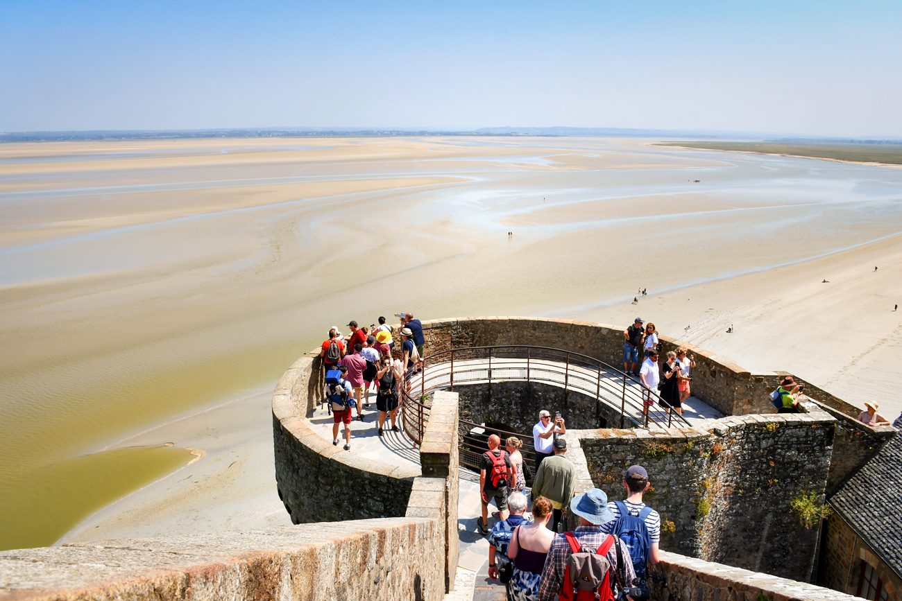
Le Mont-Saint-Michel
The epicentre of the bay is, of course, Mont-Saint-Michel! This rocky island, its village and abbey showcase France abroad, as are the Eiffel Tower and the Pont du Gard.

Mont-Saint-Michel © French Moments
Visitors can admire a splendid spectacle from the summit of Mont-Saint-Michel: the bay is adorned hour after hour with shimmering silks of gold, platinum and molten lead, constantly changing.

Historic museum of Mont-Saint-Michel © French Moments

Mont-Saint-Michel Bay © French Moments

Chemin des Fanils © French Moments
🛌 Our hotel recommandation in Mont-Saint-Michel [La Caserne]
Mercure Mont-Saint-Michel****
To find out more about Mont-Saint-Michel, read my dedicated articles:
- The abbey of Mont-Saint-Michel
- The village of Mont-Saint-Michel
- Take the Fun Quiz of Mont-Saint-Michel!
Ticket for the Abbey of Mont-Saint-Michel
Discover the Wonder of the West and explore the medieval abbey, including the Merveille and abbey church.

🚗 From the Mont-Saint-Michel car park, head towards Pontorson on the D776. To visit the Moidrey windmill: once you have passed through Beauvoir, turn left just after the Ferme d'Antan towards the "Moulin à vent de Moidrey".
Moidrey Windmill
The Moidrey mill is forty metres above sea level on a hillock overlooking the right bank of the Couesnon. It was built in 1806 and restored in 2003.
![Beauvoir Moulin de Moidrey © Nicolas Lannuzel - licence [CC BY-SA 2.0] from Wikimedia Commons](https://frenchmoments.eu/wp-content/uploads/2023/07/Beauvoir-Moulin-de-Moidrey-©-Nicolas-Lannuzel-licence-CC-BY-SA-2.0-from-Wikimedia-Commons.jpg "Beauvoir Moulin de Moidrey © Nicolas Lannuzel - licence [CC BY-SA 2.0] from Wikimedia Commons")
Moulin de Moidrey © Nicolas Lannuzel - licence [CC BY-SA 2.0] from Wikimedia Commons
The mill uses the wind to produce flour, particularly from wheat, buckwheat, rye, barley, oats, maize, rice and chestnuts. The building is a cylindrical stone structure with a conical chestnut shingle roof. It has four wings, which can be tilted to give the wind a variable surface area.
The mill is still in operation, and its miller still makes flour from buckwheat, wheat and rye. The miller gives guided tours of the mill (35 minutes).
Pontorson
The small town of Pontorson (population under 4,000) is the gateway to Mont-Saint-Michel. It is here that the trains stop so that tourists can continue their journey to the monument by a shuttle bus.
![Pontorson Eglise Notre-Dame © GO69 - licence [CC BY-SA 4.0] from Wikimedia Commons](https://frenchmoments.eu/wp-content/uploads/2023/07/Pontorson-Eglise-Notre-Dame-©-GO69-licence-CC-BY-SA-4.0-from-Wikimedia-Commons.jpg "Pontorson Eglise Notre-Dame © GO69 - licence [CC BY-SA 4.0] from Wikimedia Commons")
Eglise Notre-Dame in Pontorson © GO69 - licence [CC BY-SA 4.0] from Wikimedia Commons
Pontorson is crossed by the Couesnon (one of the three rivers in the bay of Mont Saint-Michel). In Roman times, the only way to cross the river between Brittany and Normandy was via fords.
In 1030, Robert the Devil, father of William the Conqueror, commissioned Orson, a Norman captain, to build a bridge linking the two banks. Here is the origin of Portorson: Orson's Bridge.
To see in the old town :
- Notre-Dame church (11th and 12th centuries) was built per William the Conqueror's wish by the same artisans who made the abbey of Mont-Saint-Michel.
- The Maison Guischard-de-la-Ménardière (or Romanesque house), dating from the 11th to 12th centuries.
- The Pontorson temple (or Prêche de Pontorson) is a witness to the religious struggles of the 16th and 17th centuries. It is the only Protestant church in the Manche département dating from before the French Revolution.
🚗 From Pontorson, take the D997, which becomes the D797 in Brittany. Go through Saint-Georges-de-Gréhaigne then turn left towards "Roz-sur-Couesnon - Centre bourg". After 150 m, turn right onto the D389. The road climbs to the top of the village. In the centre of the village, take the road on the right, signposted "Maison des Polders" and "Jardin Public Panorama". The town hall car park is a little further on the right.
Roz-sur-Couesnon
The main attraction of a stopover in Roz-sur-Couesnon is the panoramic view of Mont-Saint-Michel and the polders from the belvedere near the town hall.

A view of Mont-Saint-Michel from Roz-sur-Couesnon © French Moments

The belvedere of Roz-sur-Couesnon © French Moments
🚗 At the car park, turn right down the hill and take the D797 towards St Marcan and Cherrueix. In St-Broladre, turn right onto the D797 towards Cherrueix. Just after the chemist's (on your left), leave the D797 and take the small road on the right, signposted "Digue de la Duchesse Anne”. You will reach a car park with the Sainte-Anne chapel and then the long village of Cherrueix.
Digue de la Duchesse-Anne
The Digue de la Duchesse-Anne is a dyke built on an ancient barrier beach that separated the Bay of Mont Saint-Michel from the Dol marshes in northeast Brittany.
It stretches for around 36 kilometres from the Pointe de Château-Richeux (south of Cancale) in the west to the mouth of the Couesnon. It is unclear when construction began on the initiative of the Dukes of Brittany, probably in the 11th or 12th century.

© Google Earth
Once the mouth of the Couesnon had been canalised, the land to the south was progressively reclaimed until the 1930s.
Along the dyke, from Saint-Benoît-des-Ondes to the Chapelle Sainte-Anne, there are fifteen former windmills, most converted into holiday homes.
![Cherrueix Route de la Digue © Espirat - licence [CC BY-SA 4.0] from Wikimedia Commons](https://frenchmoments.eu/wp-content/uploads/2023/07/Cherrueix-Route-de-la-Digue-©-Espirat-licence-CC-BY-SA-4.0-from-Wikimedia-Commons.jpg "Cherrueix Route de la Digue © Espirat - licence [CC BY-SA 4.0] from Wikimedia Commons")
Old windmills in Cherrueix © Espirat - licence [CC BY-SA 4.0] from Wikimedia Commons
From the Chapelle Sainte-Anne, the old poplar-wooded dyke winds through the polders to the cove at Moidrey on the banks of the Couesnon.
![Sunrise © Art Anderson - licence [CC BY-SA 3.0] from Wikimedia Commons](https://frenchmoments.eu/wp-content/uploads/2023/07/Pontorson-Sunrise-©-Art-Anderson-licence-CC-BY-SA-3.0-from-Wikimedia-Commons.jpg "Pontorson Sunrise © Art Anderson - licence [CC BY-SA 3.0] from Wikimedia Commons")
Sunrise © Art Anderson - licence [CC BY-SA 3.0] from Wikimedia Commons
The new dike (Digue à la Mer), starting from the chapel, heads straight towards Mont-Saint-Michel, marking the boundary between the cultivated polders and the salt marshes.

The new dyke (Digue à la Mer) running to Cherrueix © French Moments
Chapelle Sainte Anne
The origins of St. Anne Chapel date back to the 11th century, when construction of the Duchess Anne sea wall also began. A major flood destroyed the chapel in 1630, which the villagers rebuilt in 1684.

Chapelle Sainte-Anne © French Moments
From the early 17th century, the chapel became the centre of a solemn procession organised by Antoine de Revol, Bishop of Dol. The pardon of Sainte-Anne still takes place in July.
The chapel's campanile is visible from afar, and the bell tower bears the date 1687, as does the altar, which dates from the same period.

Chapelle Sainte-Anne © French Moments
A small building at the rear of the chapel was used as a customs and coastguard post.
Cherrueix
Cherrueix is the first Breton village on the coast from Mont-Saint-Michel.
The village's three main economic activities are mussel farming, agriculture and tourism. The port of Le Vivier-Cherrueix is the leading mussel port in France. Cherrueix has transformed the shoreline into a vast beach that a significant sand yacht centre uses.

The beach of Cherrueix © French Moments
The village has a couple of beautiful thatched houses (chaumières) and a parish church dating back to the Romanesque era.

A thatched cottage in Cherrueix © French Moments
Moulin de la Saline
The Moulin de la Saline is a windmill along the Route de la Digue, located next to the Moulin de la Colimassière and the Moulin des Mondrins. The Maison du Terroir et de la Gastronomie occupies the 19th-century mill owned by the municipality.

Moulin de la Saline in Cherrueix © French Moments
From the coast on a clear day, you can see Cancale, the Chausey islands, Granville and finally Mont Saint-Michel.

The vast beach of Cherrueix © French Moments

Prés salés of Mont-Saint-Michel Bay near Cherrueix © French Moments
🚗 At Cherrueix, take the D82, which starts behind the church and runs deep inland. Shortly after the junction with the D282, turn right (V5) towards Mont-Dol. If you wish to drive to the very top of the hill, the access is near the church.
Mont Dol
The village of Mont-Dol is characterised by the mount from which it takes its name. Mount Dol, 65 m high and surrounded by the village, is part of the Dol marshes, land reclaimed naturally from the sea, unlike the polders created by man from the Sainte-Anne chapel in the commune of Saint-Broladre towards Mont Saint-Michel.

The village of Mont-Dol © French Moments
Legend has it...
Mont Dol has given rise to many legends, one of which involves the giant Gargantua.
Gargantua was walking in the bay of Mont Saint-Michel and felt his boot was in the way, so he took off his boot and shook it to get rid of the stones in the way. And so it was that the three rocks from Gargantua's boot gave rise to Mont Saint-Michel, the Tombelaine rock and Mont Dol.
Another legend involves St. Michael and the Devil. In his battle with Satan, the archangel cut a hole in the rock of Mont Dol and threw his enemy into it. But the Devil reappeared on Mont-Saint-Michel. The leap St. Michael made to reach it required such a vigorous leap that his footprint remained imprinted in the rock.

A view of Mont-Saint-Michel from Mont-Dol © French Moments
Monuments at the hilltop
Several monuments occupy the top of the hill.
- Two windmills, including the Moulin du Tertre, built in 1843 and open to visitors.
- An old farm building.
- The Notre-Dame-de-l'Espérance tower is an octagonal tower dating from 1857 supporting a giant statue of the Virgin. You can climb to the upper platform for a breathtaking view of the Dol marshes, the sea and Mont-Saint-Michel.
- Saint-Michel Chapel (1857).

The chapel and the view from the belvedere of Mont-Dol © French Moments

The windmill of Mont-Dol © French Moments
🚗 Leave Mont-Dol on the D123, then turn left onto the D155 towards Dol-de-Bretagne.
Dol-de-Bretagne
The historic town of Dol-de-Bretagne is the first Breton town to emerge from Normandy.
Dol Cathedral
At the heart of this charming town is the magnificent Cathedral of Saint-Samson, a true architectural marvel.

The nave of the cathedral © French Moments
This 12th- and 13th-century Gothic cathedral symbolises grandeur and elegance with its Gothic-style architectural details. Visitors are greeted by a serene and sacred atmosphere, with colourful stained glass windows dating back to the 13th century.

The main altar and the nave © French Moments

The beautiful medieval stained-glass windows © French Moments
The old town of Dol
Strolling through the cobbled streets of Dol-de-Bretagne, you'll also discover other treasures, such as the Maison des Petits-Palets (a Romanesque house reputed to be the oldest in Brittany), pretty, colourful half-timbered houses, picturesque squares and an authentic atmosphere that will transport you back in time.

The Romanesque House in Dol-de-Bretagne © French Moments
You will discover most of the landmarks along Grande Rue des Stuarts, the town's high street, continued by Rue Jejamptel.

Brittany Unveiled: Dol-de-Bretagne © French Moments

The local boulangerie-pâtisserie © French Moments
Rue Ceinte connects the high street to the cathedral and offer a picturesque view of the old town.
🛌 Our hotel recommandation in Dol-de-Bretagne
Kyriad Dol-de-Bretagne***
🚗 After this short foray into the Dol marshes, take the D155 back to the coast to Le Vivier-sur-Mer.
Le Vivier-sur-Mer
The village stretches along the D 155 road, which follows the route of the Duchesse-Anne dyke.
Le Vivier-sur-Mer is the main mussel production centre in northern Brittany.
Mussel cultivation
During the second half of the 20th century, the village underwent profound changes as mussel farming developed in the bay thanks to the arrival of professionals from the Charente region from 1955 onwards.
Bouchot mussel cultivation grew exponentially in Mont-Saint-Michel Bay, with a concentration of onshore installations around the port of Le Vivier-sur-Mer.
The alignments of piles used to produce the mussels, known as bouchots, now stretch over a total length of 270 km, covering an area of 1,000 hectares. With an annual production of 10,000 to 12,000 tonnes of mussels, the Bay of Mont-Saint-Michel has become France's leading centre for the production of mussels on bouchots.

Mussel and oyster seller in Le Vivier-sur-Mer © French Moments
Bouchot mussel culture
Bouchot culture is a specific method used for cultivating mussels. It involves pilings, referred to as "bouchots" in French, driven into the intertidal zone seabed.
Ropes are then wrapped in a spiral around these pilings, providing a substrate for the mussels to attach and grow.
Additionally, mesh netting prevents the mussels from detaching and falling off the ropes.
This technique requires a suitable tidal range, as the mussels need exposure to both water and air during the tidal cycle for optimal growth.
Bouchot culture has proven to be an effective and sustainable method for cultivating high-quality mussels in coastal areas.
Visit of the mussel and oyster fields
The Maison de la Baie du Mont-Saint-Michel offers fascinating bay tours at low tide, either on foot or on the "Mytili-Mobile" (little train). Here you will discover the flora and fauna of the Bay, as well as the maritime industry (mussel and oyster farming). The outings "Mytili huîtres" (oysters) or "Mytili bouchots" (mussels) are guided by qualified specialists.

The little train of Cherrueix similar to that in Le Vivier-sur-Mer © French Moments
🚗 Follow the scenic route along the coast, taking the D155 through the villages of Hirel, Vildé-la-Marine and Saint-Benoît-des-Ondes. Then take the D76 towards Cancale. As you approach Cancale, turn right onto the C5, following the signs for "Route de la Baie". From this panoramic road, you'll enjoy beautiful views over Cancale before reaching the old port.
Cancale
When you visit Cancale, you'll be immersed in the essence of Breton maritime life, discovering a destination combining gastronomy, history and spectacular seascapes.
The picturesque town of Cancale is a paradise for seafood lovers and seascape enthusiasts.

Cancale Oysters © French Moments
Port de la Houle
The town is famous for its delicious oysters and its historic old port. Stroll along the old harbour (Port de la Houle), and you'll be captivated by the lively atmosphere and the colourful fishing boats gently bobbing on the waters. Local restaurants offer a variety of fresh seafood, including the famous Cancale oysters, which you can enjoy while admiring the breathtaking sea views.
![Cancale © W. Bulach - licence [CC BY-SA 4.0] from Wikimedia Commons](https://frenchmoments.eu/wp-content/uploads/2023/07/Cancale-©-W.-Bulach-licence-CC-BY-SA-4.0-from-Wikimedia-Commons-scaled.jpg "Cancale © W. Bulach - licence [CC BY-SA 4.0] from Wikimedia Commons")
Port de la Houle, Cancale © W. Bulach - licence [CC BY-SA 4.0] from Wikimedia Commons
![Cancale. Photo by AntonSorokoletov [public domain via Wikimedia Commons]](https://frenchmoments.eu/wp-content/uploads/2023/07/Cancale.-Photo-by-AntonSorokoletov-public-domain-via-Wikimedia-Commons-scaled.jpg "Cancale. Photo by AntonSorokoletov [public domain via Wikimedia Commons]")
Cancale Harbour. Photo by AntonSorokoletov [public domain via Wikimedia Commons]
Upper Town
The narrow, winding streets of the town centre invite you to take a pleasant stroll, offering charming boutiques and traditional stone houses that witness the town's rich history.

Church of Cancale © French Moments
Pointe du Hock
Remember to follow the Sentier des Douaniers, an ancient coastal path from the harbour up to the Pointe du Hock. This fantastic vantage point overlooks the sea, the rock of Cancale and the silhouette of Mont-Saint-Michel in the distance.
![Cancale Pointe du Hock © Fanfwah - licence [CC BY-SA 4.0] from Wikimedia Commons](https://frenchmoments.eu/wp-content/uploads/2023/07/Cancale-Pointe-du-Hock-©-Fanfwah-licence-CC-BY-SA-4.0-from-Wikimedia-Commons-scaled.jpg "Cancale Pointe du Hock © Fanfwah - licence [CC BY-SA 4.0] from Wikimedia Commons")
Pointe du Hock and the oyster fields of Cancale © Fanfwah - licence [CC BY-SA 4.0] from Wikimedia Commons
🛌 Our hotel recommandation in Cancale
La Mère Champlain***
🚗 At Cancale, follow the D201 northwards. The road will take you directly to the Pointe du Grouin car park, from where you can continue on foot to the site.
Pointe du Grouin
The Pointe du Grouin is part of the municipality of Cancale. The cape is the most westerly projection of Mont-Saint-Michel Bay, and from here begins the beautiful Emerald Coast towards Saint-Malo and Cap Fréhel.

Pointe du Grouin © French Moments
This rocky outcrop, sculpted by the waves and winds, is a natural jewel that attracts crowds, especially in summer. Strolling along the coastal paths, you'll be overwhelmed by this place's wild, unspoilt beauty. The sheer cliffs, secluded coves and spectacular rock formations create an impressive backdrop.

Ile des Landes © French Moments
The Pointe du Grouin is also an ideal vantage point for admiring the marine wildlife, such as seabirds and seals, that inhabit these waters. The Ile des Landes, opposite the Pointe du Grouin, is a protected ornithological and botanical reserve.
This iconic spot offers breathtaking views of the sea and breathtaking coastal scenery. The view stretches across Mont-Saint-Michel Bay to Granville. On a clear day, you can also see the Chausey Islands.

A view of Mont-Saint-Michel from Pointe du Grouin © French Moments
🚗 From the Pointe du Grouin, you can follow the D201 to Saint-Malo. The scenic route follows the Emerald Coast and its beautiful beaches.
Further away
The bay is located right on the border between Normandy and Brittany.
These two culturally rich regions allow visitors to experience French culture after visiting Mont-Saint-Michel.
Towards Brittany
From Cancale to Saint-Malo, the Emerald Coast has stunning hidden beaches such as Plage du Verger and Plage du Guesclin.

Fort du Guesclin © French Moments
An hour away from Mont-Saint-Michel lies the town of Saint-Malo, another fortified town whose harbour hosts regular trips between France and England (Portsmouth).

Brittany Unveiled - Saint-Malo © French Moments
In the southwest, the historic town of Dinan is well worth a visit, with its beautiful half-timbered houses, ramparts and old port on the River Rance.

Explore Dinan - Rue du Petit Fort © French Moments
Towards Normandy
In Normandy, Mont-Saint-Michel Bay is only one and a half hours away from Caen and the D-Day Beaches where the Allies’ landing occurred in June 1944.
The Caen Memorial, telling the story of the Second World War with unique documents, is worth a visit.
![Caen © Roi.dagobert - licence [CC BY-SA 3.0] from Wikimedia Commons](https://frenchmoments.eu/wp-content/uploads/2023/07/Caen-©-Roi.dagobert-licence-CC-BY-SA-3.0-from-Wikimedia-Commons-scaled.jpg "Caen © Roi.dagobert - licence [CC BY-SA 3.0] from Wikimedia Commons")
Caen © Roi.dagobert - licence [CC BY-SA 3.0] from Wikimedia Commons
It is also awe-inspiring to walk around the different D-Day Beaches, from Utah to Sword, passing by Omaha, with its American graveyard and the remains of German bunkers and the coastal village of Arromanches, where you can still see some elements of the artificial harbour, which permitted the Allies to disembark soldiers and materials.
![Explore Normandy - Arromanches © Comité Régional du Tourisme de Normandie - licence [CC BY-SA 3.0] from Wikimedia Commons](https://frenchmoments.eu/wp-content/uploads/2018/09/Arromanches-Explore-Normandy-©-Comité-Régional-du-Tourisme-de-Normandie-licence-CC-BY-SA-3.0-from-Wikimedia-Commons.jpg "Arromanches Explore Normandy © Comité Régional du Tourisme de Normandie - licence [CC BY-SA 3.0] from Wikimedia Commons")
Arromanches © Comité Régional du Tourisme de Normandie - licence [CC BY-SA 3.0] from Wikimedia Commons
Not far from here is Bayeux, famous for its medieval Tapestry. This 70 metres long, extremely detailed tapestry is a precious item of heritage that tells us the story of the conquest of England by William, Duke of Normandy.
![Bayeux © Mairie de Bayeux - licence [CC BY-SA 4.0] from Wikimedia Commons](https://frenchmoments.eu/wp-content/uploads/2023/07/Bayeux-©-Mairie-de-Bayeux-licence-CC-BY-SA-4.0-from-Wikimedia-Commons-scaled.jpg "Bayeux © Mairie de Bayeux - licence [CC BY-SA 4.0] from Wikimedia Commons")
Bayeux © Mairie de Bayeux - licence [CC BY-SA 4.0] from Wikimedia Commons
A fun fact, Mont-Saint-Michel is depicted in the tapestry when William and his army embark on England.

More info about Mont-Saint-Michel
Useful links
- Our blog article on Mont Saint-Michel Abbey
- Buy your priority entrance tickets to the abbey
- The official website of the Mont-Saint-Michel Abbey
Stay overnight in Mont Saint-Michel
We visited Mont Saint-Michel during the day. As it was mid-June, the sun was setting very late, and our family couldn't stay that late on the site.
However, I would have liked to admire the Mount at nightfall, see it illuminated and take a night-time tour of the abbey.

Mont-Saint-Michel Abbey by night. Photo by wirestock via Envato Elements
That said, it is possible to stay overnight. You have two options for booking a hotel room:
In the village
There are less than ten hotels in the medieval village, located along the Grande Rue (click on each link for more info):
- La Mère Poulard,
- Le Mouton Blanc,
- Les Terrasses Poulard,
- Auberge Saint-Pierre,
- La Vieille Auberge,
- La Croix Blanche.
When it comes to views from the rooms, you're spoilt for choice: some overlook the bay, others the village or the abbey.

The village view from the Chemin de Ronde © French Moments
More options
If you want to stay overnight at Mont Saint-Michel, I invite you to click on this link for suggestions of accommodations or simple browse the map below:
English-French Vocabulary
(f) for féminin, (m) for masculin, and (v) for verbs

abbey
archangel
bay
beach
bridge
Brittany
to build
car park
chapel
church
cliff
dam
dyke
English Channel
fortification
Gothic art
island
islet
lamb
land reclamation
marsh
Middle-Ages
mount
mussel
Normandy
ossuary
oyster
pilgrim
river
Romanesque art
sea
sheep
St. Michael
tide - low - high
village

abbaye (f)
archange (v)
baie (f)
plage (f)
pont (m)
Bretagne (f)
construire (v)
parking (m)
chapelle (f)
église (f)
falaise (f)
barrage (m)
digue (f)
Manche (f)
fortification (f)
art gothique (m)
île (f)
îlot (m)
agneau (m)
poldérisation (f)
marais (m)
Moyen-Âge (m)
mont (m)
moule (f)
Normandie (f)
ossuaire (m)
huître (f)
pélerin (m)
rivière (f)
art Roman (m)
mer (f)
mouton (m)
Saint Michel (m)
marée (f) basse - haute
village (m)
Did you enjoy the reading? If so, share it on Facebook or Twitter! 👍
🎯 You can also pin these images on Pinterest:


