
I've always had a passion for geography. I'm crazy about road maps. I can't say it's a passion, but whenever the opportunity arises, I could spend hours with my nose plunged into road maps of France, starting with the maps of Alsace and Lorraine!
I love immersing myself in the tangle of those sinuous red or yellow lines, the touches of greenery or the marks of relief, the kilometre distance figures lined up between two localities, and those evocative names that feed my imagination: Aix-les-Bains, Amboise, Menton...
As proof of my interest in maps, I recently bought a laminated road map from Michelin to cover a wall in my office.
So when Léo sent me an email, it piqued my interest.
Léo's website offers a collection of thousands of old maps. Cassini maps, IGN maps, staff maps, city maps, finding the correct map for yourself (or to give as a gift) can be a long and tedious task. Léo is here to help, and he's got it all covered!
His blog is a mine of fascinating information for map fans, with articles dedicated to old maps (design, history, anecdotes).

About the maps of France
Before I reveal the maps that Léo sent me, I'll let him tell us the fascinating story of the cartography of Alsace and Lorraine.
Alsace and Lorraine: thriving cartography regions
Alsace and Lorraine, two emblematic regions on the border between France and Germany, have a rich and complex history.
Because of their strategic location, these lands have been the scene of many cultural and political influences over the centuries.
Cartography, the process of representing these territories geographically, has played a crucial role in understanding and analysing their diversity.
In this article, we explore the importance of cartography in Alsace and Lorraine, focusing on their multiculturalism, tumultuous history and the significant presence of old maps on the market.
![Carte du Département du Haut-Rhin en 1860 [Domaine Public via Wikimedia Commons]](https://frenchmoments.eu/wp-content/uploads/2023/08/Carte-du-Departement-du-Haut-Rhin-en-1860-Domaine-Public-via-Wikimedia-Commons.jpg "Carte du Département du Haut-Rhin en 1860 [Domaine Public via Wikimedia Commons]")
Map of the Haut-Rhin département in 1860 [Public Domain via Wikimedia Commons]
A multicultural and economically prosperous area
Alsace and Lorraine are regions that have often found themselves at the crossroads of cultures.
Their privileged geographical position has made them attractive to many peoples throughout history, contributing to their cultural diversity.
From Celtic to Germanic and Roman influences, these lands have witnessed the emergence of a unique blend of traditions and identities.
This multicultural environment has encouraged cartographers to study these regions closely better to understand their geographical, social and economic characteristics.
By mapping these territories, they could analyse their natural resources, communication routes, economic centres and borders, thereby promoting the development and prosperity of these regions.

Traditional Alsatian costumes by Jebulon. Public domain via Wikimedia Commons
A historically coveted and intensely mapped area
The turbulent history of Alsace and Lorraine has been marked by periods of conquest and domination by various empires and kingdoms.
Over the centuries, these lands have been coveted by French and German armies, who have vied for their control.
This geopolitical challenge has led to an intensification of cartography in the region.
The French 'Etat-major' in the 19th century
It is fascinating to note that at the beginning of the 19th century, the French General Staff decided to map the whole of France. The idea was to update the Cassini maps, which had become increasingly obsolete. Alsace and Lorraine were among the first regions to be mapped!

Maps of France (Alsace-Lorraine) - Cartes de Léo
Between 1871 and 1918
In the 19th century, when Germany annexed Alsace and Moselle, the German government also undertook a vast programme of military mapping to control these newly acquired regions better.
Detailed topographical maps were essential for military operations and land management.
After 1918
Similarly, when Alsace and Moselle returned to French control at the end of the First World War, the French army also carried out cartographic surveys to assert its authority over the territory.
This rivalry left a significant mark on the region's cartography.
An important range of old maps of Alsace and Lorraine
The cartographic heritage of Alsace and Lorraine is still very much alive today.
Old maps of these regions are much sought-after by collectors, historians and cartography enthusiasts, and there's plenty on offer too!
These maps offer a unique insight into these lands' geographical, political and cultural development over time.
These old maps, with their meticulous detail and artistic illustrations, are fascinating witnesses to the eventful history of Alsace and Lorraine. They are also invaluable collector's items for art and history lovers.

Maps of France - Cartes de Léo
In Conclusion
Alsace and Lorraine, rich in multiculturalism and complex history, have been the scene of intensive cartography over the centuries.
Maps were drawn and produced to understand and analyse these coveted territories.
Today, old maps of Alsace and Lorraine continue to fascinate cartography and history enthusiasts.
These maps are veritable historical treasures for collectors and art lovers, bearing witness to a bygone era.
For those wishing to acquire an old map of these regions, specialist galleries and online auction sites are offering rare and unique pieces.
My Maps of France Order
So Léo sent me two maps that I'd like to introduce to you, as well as his service.
First of all, I told him about my favourite places. I wanted a general map of France and another in Alsace. Léo got back to me within 24 hours with several customised proposals.
So I chose :
- an ‘Etat-Major’ map of the Colmar region,
- an old map of France between 1871 and 1918.
Delivery was fast and careful. Although I live in England, the maps arrived in perfect condition with no problem!

The 'Etat-Major' map of Colmar
The map was drawn up by French staff officers and published in 1837. However, the present map is a revision from 1911 - when the region was under German rule.

This map reveals some pleasant surprises. Today's roads between the various towns are easily recognisable.

Then, to the north, look out for Schlestadt, the former name of Sélestat.

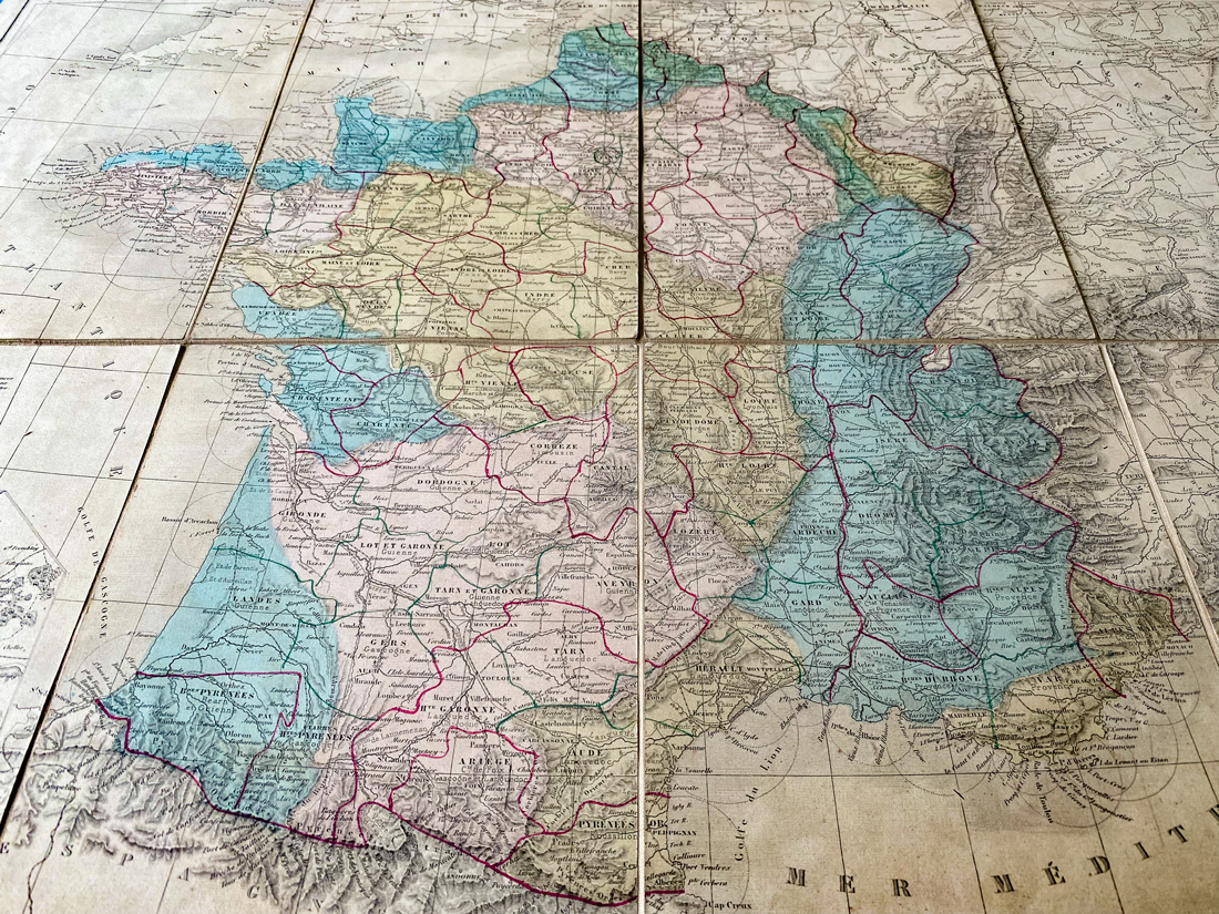
The Map of France
I had asked for an old map of France showing the separation of Alsace-Moselle, a territory allocated to Germany by the Treaty of Frankfurt in 1871.

The major basins of the French rivers can be seen: the Seine, the Loire, the Garonne and the Rhône.
Here too, the place names hark back to the past. There are the départements of Seine (now Paris), Côtes-du-Nord (Côtes d'Armor), Basses-Alpes (Alpes-de-Haute-Provence) and Basses-Pyrénées (Pyrénées Atlantiques).

The insert on the Paris region is also interesting, with the reference to the "annexed zone" around Paris. This refers to the annexation by Paris of several neighbouring communes in 1860 (Montmartre, Belleville, Grenelle, Auteuil, Passy, etc.).

Unsurprisingly, the map shows the department of Seine-et-Oise, which until 1968 included the current departments of Essonne, Seine-Saint-Denis, Hauts-de-Seine, Yvelines and Val d'Oise.
Charleville-Mézières is represented by two separate communes - those before the 1966 merger: Mézières and Charleville.
Finally, a small but interesting detail: the Meurthe-et-Moselle département is presented under the name Moselle-et-Meurthe!

Treat yourself to vintage Maps of France!
If you're passionate about old maps or would like to give some as a gift, visit the Cartes de Léo website! And like us, immerse yourself in maps full of history and adventure.
Cartes de Léo make great birthday or Christmas gifts, so don't forget them if you want to give something original 🙂
