
The Calanques of Cassis are a unique geological formation in Provence, usually comprised of limestone or granite; they are made up of deep, narrow valleys with sharp edges, partly submerged by the sea. Their shapes are very similar to those of the Norwegian fjords. These formations are often found in coastal Mediterranean areas, particularly south-eastern France, where the sea has carved geological crevices, like emerald fingers reaching between the rocks, which have lead to a beautiful display of sharp peaks and colossal fortresses.
General overview of the Calanques
There are many Calanques along the coast of Marseille and in surrounding regions (Ensues la Redonne, Cassis, La Ciotat, Port d’Alon, Saint Cyr-sur-Mer). The water temperature around these Calanques is often colder, as the cliffs fall directly into the sea without any coastal plateau. However, this colder temperature is also due to a number of streams which flow into the sea at this location, meeting the ocean below sea level.
The streams are part of a complex underground network of tributaries which collect water from the Marseilleveyre Mountains and the Carpiagne plateau. For example the sea water around the Calanque of ‘Port Miou’ comes from the Sainte Baume mountain range.
All limestone coasts have experienced this phenomenon of underwater streams at some stage as a result of changes in sea level over time. Water levels lowered by approximately 135 metres before rising again and thus drowning the springs and streams some 12,000 years ago during the slow warming of the earth after the Ice Age.
Between five and seven million years ago, the sea in the Mediterranean Sea supposedly almost disappeared when its level lowered by approximately 1 500 metres. The mountainous mass of the Marseille Calanques is 20 km long and 4 km wide. Spreading over 7200 hectares, it stretches between the Goudes (south west of Marseille) and Cassis. Its highest points are the mountain of Marseilleveyre at 432 metres and Mount Puget at 565 metres.
In the past, men used to graze sheep and built sheepfold and lime oven in the Calanques, the ruins of which can still be found there. The only remains of this human occupation are the fishing cabins of Sormiou and Morgiou.
The Calanques are one of the most popular sites in France, welcoming over 1.3 million visitors per year. All this tourist activity is closely monitored in order to prevent damage to the fragile environment of the Calanques.
Flora and Fauna in the Calanques
They do indeed play host to a very unique type of ecosystem, which includes precious fauna and flora. The climate is arid and soil is quasi non-existent because of the limestone cliffs topped by debris and fallen rocks. Chinks and cracks are thus the only place for vegetation to take root. These, combined with the constant exposure to salt spray, means that only xerophyte plants such as heath, sarsaparilla, pine trees, ferns and juniper trees can grow in these areas. A study undertaken listed 26 different types of natural habitat in the Calanques and to that must be added 40 mixed habitats.
Eight-three species living in the Calanques are protected nationally or regionally, which makes the site a valuable natural environment. Species such as the Sabline de Provence grass (or “gouffé”) only exist in the Calanques and several rare birds like the eagle owl and the Bonelli’s eagle can be found there too.
Fires pose a large threat in a climate as dry as that of south-eastern France, particularly in the Calanques as they are exposed to winds. On average, there is one large fire there every 15 years. In fact, the the last one, in 1990, destroyed 3,500 hectares, which equates to almost half of the Calanques range.
Activities in the Calanques
There are many winding paths which are perfect for hikers and tourists who wish to discover the Calanques; some can take several days to complete, such as the GR51 which crosses the range from west to east over 28km. Other paths can be covered in just over an hour. Most of them are very well maintained and although night hiking and camping are not allowed, the choice of leisurely walks is delightfully varied. However, one must be conscious of the weather, given the strength of the Mistral wind in Provence. The Calanques can also be visited by boat, which is certainly a faster and less exhausting means to discover them. Many boat companies have shuttle boats stationed in Marseilles’ Vieux-Port, leaving every thirty minutes for tours of the Calanques.
In addition, nautical activities such as wind surfing, kayaking and snorkelling are also undertaken in the Calanques.
A National Park in the making?
Given their uniqueness and their richness of flora and fauna, a plan is currently underway to push for the Calanques to be declared a National Park in order to protect them. It is estimated that this plan will be finalised by June 2011, when this area will become the first peri-urban park of its kind in Europe. As the result of an agreement between local governments and state representatives and associations as well as more than ten years of planning, this National Park scheme will encompass five municipalities: Marseille, Cassis, La Ciotat, Ceyreste et Roquefort-la-Bédoule and it will cover 11,200 hectares of ground and 48,000 hectares of ocean.
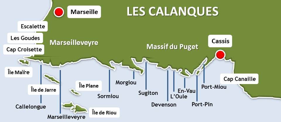
The Calanques
GOUDES:
The suburb of Goudes is part of the 8th ‘arrondissement’ of Marseille. Its little harbour and authenticity make it a very beautiful place. It is accessible by car but be weary of traffic, as there is only one road leading into the region and thus it often takes several hours to actually reach Goudes on weekends and during the holidays.
CALLELONGUE:
Located between Marseille and Cassis, Callelongue is the first of the Calanques. It is located at the south east extremity of Marseille’s 8th ‘arrondissement’, after the village of Goudes, at the end of the road which borders the ocean.
MARSEILLEVEYRE:
The calanque of Marseilleveyre may be small but it is very popular because of its breath-taking view over the Riou Island.
SORMIOU:
The Sormiou Calanque is notorious for its rock-climbing tracks, even though the main site for this activity is actually En-Vau. The Sormiou Calanque is one of the most famous and most visited Calanques amongst the Marseillais (the Marseille region) and access to it is well maintained. Indeed the road leading to it is well hidden, as though Marseille were trying to keep its greatest riches only for the connoisseurs. This Calanque has excellent vehicular access outside of the summer period though the best way to discover it is still on foot, having the Parc des Baumettes as a starting point. Access is through either the Cayolle or the Baumettes and, before long, you will be delighted by the spectacular view over the sea and the Riou, Plane and Jaïr islands, which is all visible from the pass of Sormiou. Access from Marseille is easy; by car, pass through the neighbourhood of Mazarues in the direction of Les Baumettes and then Morgiou (however, this road is closed in the summer and during the autumn and spring weekends). If you plan to travel by bus, take the Number 22 as far as Les Baumettes or the Number 23 to the terminus Morgiou-Beauvallon, then walk for 45 minutes. A particularly unique aspect of this Calanque is that it is inhabited (about a hundred cabins) and it hides a little harbour, protected by a dam. Its water also turns turquoise in during summer, a rather uncommon happening in the Mediterranean. Unfortunately though, the Sormiou Calanque was ravaged by a fire in 1998.
MORGIOU:
The Calanque of Morgiou is a typical, little fishing harbour with only a few buildings. Nearby, the Calanque de la Triperie is known for the Cosquer cave, whose entrance is 37 metres below sea level. Discovered by Henri Cosauer in 1991, the underground cave shelters prehistoric paintings dating back to the period 27,000 – 19,000 BC, and representing both terrestrial and marine animals such as horses, ibexes, seals, penguins and others. One of the beach’s distinctive features is the fact that naturism is practised there and also the Torpedo Boat Rock (or the Swan) which emerges near the shore. It is for this reason that the Morgiou Calanque is sometimes confused with the Calanques ‘des pierres tombées’ (of fallen rocks) to which access is now closed due to a lethal rock fall. Access from Marseille involves a trip to the University of Luminy (via car or the bus Number 21, except on weekends and holidays) followed by a walk of about an hour.
SUGITON:
Although very small, this Calanque is well known for the beautiful colour of its water as well as for its easy access. Indeed the Sugiton Calanque is one of the only to be open to tourists during the hot season.
L’ŒIL DE VERRE (The glass eye):
An underground cave with prehistoric paintings, demonstrating the wonders of nature while simultaneously informing us about the history of humanity.
DEVENSON:
The dizzying cliffs of the Devenson Calanques resemble giant organ drums sliding down into the green water below, which makes them a truly astounding spectacle.
L’OULE:
A little cove, extremely difficult to access, the Calanque of l’Oule benefits quite simply from its proximity to the En-Vau and the Devenson Calanques.
EN-VAU:
The Calanque of En-Vau is without a doubt one of the most beautiful and most impressive Calanques. Its cliffs are extremely high and it is a very popular climbing site, which looks like a tongue embedded into the cliffs, surrounded by pine trees. The beach is predominately sand and pebbles but the sea is clear and turquoise. Access to the Calanques is a tough hike and thus this little bit of paradise is reserved only to the most deserving. From Port-Pin, it takes an hour of walking in order to reach the Calanque. From the parking lot at the Gardiole, the return trip will take approximately 3 hours and the path is closed in summer. It is also possible to access the En-Vau Calanque from the beach of Cassis or the Port Miou Calanque, by canoe.
PORT-PIN:
The Port Pin Calanque is very pretty and very easy to access, which means it is highly frequented. The beach is a combination of sand and pebbles and there is good vegetation coverage, making it ideal for sunbathers. Access from Cassis via Port Miou is a thirty minute walk but care must be taken when walking on the limestone paths, which have been made slippery due to the high numbers of visitors crossing them.
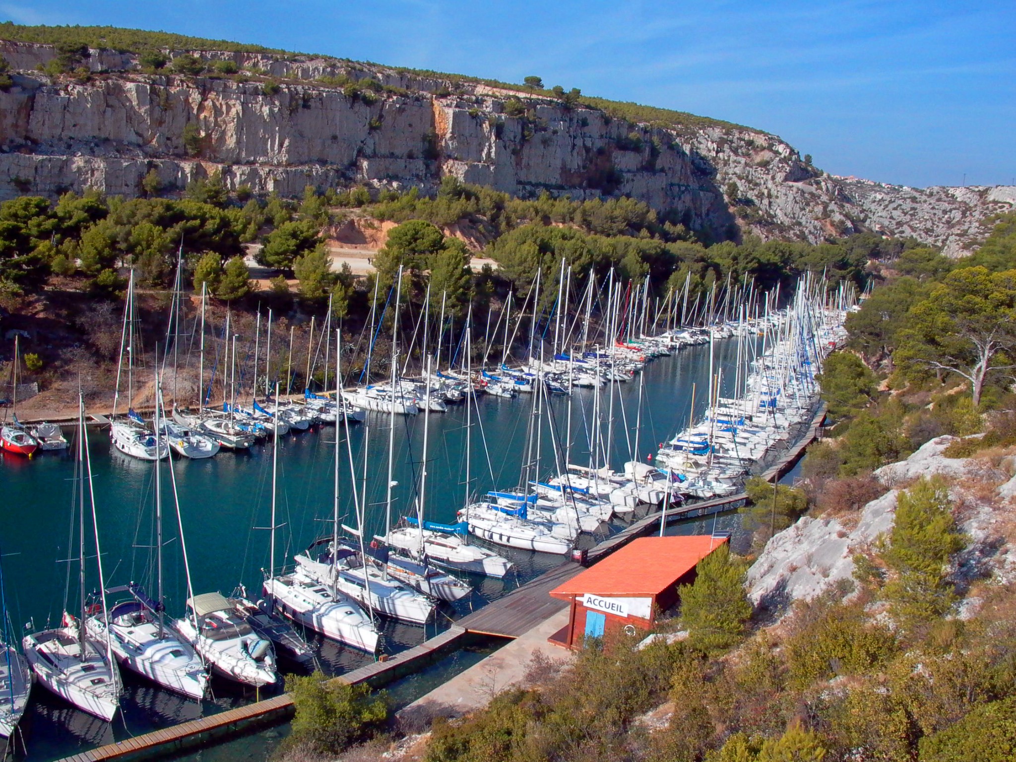
PORT-MIOU:
Port Miou is the little sister of Cassis and attracts a lot of walkers from the Pailladou onwards. As its name indicates, the Port Miou Calanque’s primary function is as a harbour and does not possess a beach. It is the closest Calanque to Cassis (only 30 minutes walk from the city centre). Port Miou is close to the starting point for those who undertake the hike of the Calanques from Cassis, which can also be accessed directly by car from the peninsula of Cassis. The peninsula that goes along the Calanque is a good departure point for the Calanques of Port-Pin (30 minutes walk) and En-Vau (an hour and a half walk) and it is a very nice place to spend the day given the numerous activities on offer (canoe rental, restaurants, tennis club…).
CASSIS:
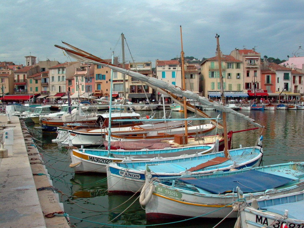
Cassis is on the edge of the Mediterranean Sea, 20 km east of Marseille. It is particularly famous for the Calanques and their cliffs. Cassis counts two listed sites along its 11km of coast: the Calanques themselves, which have been listed since 1975, and the Cap Canaille range, since 1989. Occupation of the site dates back to 500 or 600 BC and was probably under Greek and then Roman influence. From the 18th century onwards, Cassis broke out of its walls and started expanding around the harbour. The little town is also renowned for its rock (quarries exist there which have been used since ancient times), and also for its wine (both white and rosé). Cassis’ main sources of income are tourism, fishing and viticulture. Sites to visit in Cassis, besides the Calanques and Cap Canaille, include the harbour, the castle (which is privately owned) and the chapel Notre Dame Bon Voyage.
CAP CANAILLE:
Between Cassis and La Ciotat, 20km east of Marseille, stands the Cap Canaille which, at 400 metres high, is the highest maritime cliff in Europe. To get to the Cassis Calanques, you need to follow the Route des Crêtes (crest road) between Cassis and La Ciotat. This road is very winding and scarped and requires the utmost vigilance when driving.
Visit the Official Website of the National Park of the Calanques
Featured image: Calanque of Port-Miou © Olivier Risnes

